👻 HAUNTED PLACE · EXP. Nº9475
ACTIVE
Sargasso Sea
The Sargasso Sea is the only sea on Earth without a coast: some 4.16 million km² of the North Atlantic, bounded not by land but by four currents turning clockwise around it, and holding on its surface a brown alga that never touches the seabed at any point in its life.
Where is Sargasso Sea?
- Location
- Unknown
- Type
- Sea / open ocean
- Coordinates
- 30.0, -60.0
- Last updated
LOCATION
Why is Sargasso Sea said to be haunted?
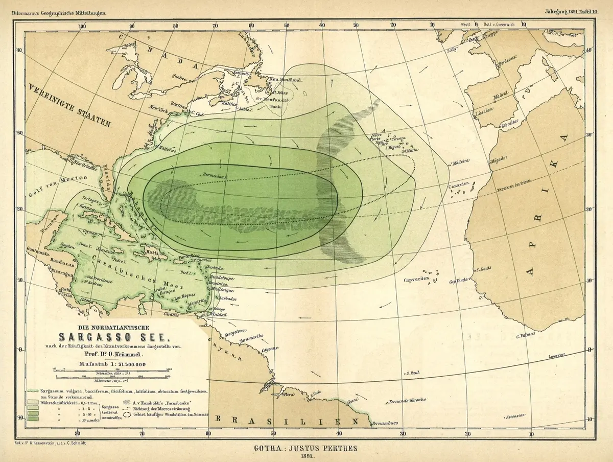
Its reputation is that ships get caught in the weed and rot there. That reputation is traceable, and it is wrong. Columbus sailed through it in September 1492 and his log records the crew cheering, because they read the weed as a sign of land; on the day the sea seemed «curdled» with it the fleet still made thirteen leagues. Otto Krümmel's 1891 chart, the map on this page, grades the sea by the probability of meeting drifting Sargassum, and its darkest class is ten per cent. What actually becalms a ship here is the windless high of the horse latitudes — not the doldrums, which lie two thousand kilometres south. The real unsolved question is quieter: a century after the eels of Europe were traced to this water, nobody has ever found one spawning.
What is the history of Sargasso Sea?
The Sargasso Sea is the one sea on Earth that nobody can stand beside. It has no coast. Its edges are four moving currents — the Gulf Stream to the west, the North Atlantic Current to the north, the Canary Current to the east, the North Atlantic Equatorial Current to the south — turning clockwise inside the North Atlantic subtropical gyre. Because those currents shift, so do the boundaries, which is why the sea has been given different dimensions by every authority that has tried. The Sargasso Sea Alliance settled the question pragmatically in 2011 by commissioning a map from current and eddy occurrence, satellite detection of weed and seabed topography: an area of roughly 4,163,499 km², extending between 22°–38°N and 76°–43°W and centred on 30°N, 60°W. That map was adopted three years later as Annex I of the Hamilton Declaration. Inside all that water there is exactly one piece of land: Bermuda.
The name is Portuguese. Sargaço is the weed, and the weed is Sargassum, a brown alga that in this one place is holopelagic — it never touches the seabed at any point in its life, floating and dividing on the open ocean, which is what NOAA singles out as the sea's unique quality.
The most quoted witness is Christopher Columbus, and the record does not say what the legend says it says. Columbus's own log is lost; what survives is the abstract made by Bartolomé de las Casas, and it can be read line by line. On Sunday 16 September 1492 the fleet begins to see "muchas manadas de hierba muy verde" — great herds of very green weed — and the reaction recorded is not dread but hope: "todos juzgaban que estaban cerca de alguna isla", everyone judged they were near some island. The next day there is more of it, they fish a live crab out of it and the Admiral keeps the crab as proof, and the entry ends with the whole fleet racing: "Iban muy alegres todos y los navíos quien más podía andar andaba por ver primero tierra."
The fear that is actually written down is the opposite of the one the legend supplies. On Saturday 22 September, in Columbus's own words inside the abstract, a contrary wind is welcome: "Mucho me fue necesario este viento contrario, porque mi gente andaban muy estimulados, que pensaban que no ventaban estos mares vientos para volver a España." His men were not afraid of being held by weed and starving. They were afraid that in these seas no wind ever blew back — that they could sail out and never sail home. The following day the sea rose without wind and Columbus, in the same abstract, compares his relief to the parting of the waters for Moses.
And the crossing itself can be checked with arithmetic. The heaviest weed of the whole voyage is logged on Friday 21 September, when "hallaron tanta hierba que parecía ser la mar cuajada de ella" — so much weed that the sea seemed curdled with it. They made thirteen leagues that day, slowed by calm, not by weed; the day after that, thirty. The weed thins out and by Friday 5 October the entry reads "hierba ninguna", none at all. Landfall came a week later. Nineteen days of intermittent weed and not one day stopped.
The scientific career of the sea begins properly with Matthew Fontaine Maury's The Physical Geography of the Sea (1855), and it is worth noting where he put it: "Midway the Atlantic, in the triangular space between the Azores, Canaries, and the Cape de Verd Islands" — the eastern side of the ocean, not the western basin the name denotes today. In §13 Maury describes an area the size of the Mississippi valley "so thickly matted over with Gulf weed (fucus natans), that the speed of vessels passing through it is often much retarded", adds that "to the eye, at a little distance, it seems substantial enough to walk upon", and explains the accumulation with the image every later writer borrowed: cork in a basin of water given a circular motion gathers at the quiet centre.
Measurement replaced impression in 1891, and the result is the picture at the head of this file. Otto Krümmel's plate for Petermanns Geographische Mitteilungen (Jahrgang 1891, Tafel 10; Gotha: Justus Perthes; scale 1:31,300,000) is titled "the North Atlantic Sargasso Sea, represented according to the frequency of weed occurrence". Krümmel had compiled ship reports and shaded the ocean in four probability classes. He also drew, as a separate dotted outline, the "Gebiet häufiger Windstillen im Sommer" — the area of frequent summer calms — and marked Alexander von Humboldt's Fucusbänke, the weed banks of the older literature. Krümmel's map keeps apart the two things the legend fuses.
The botany was settled by Frank S. Collins in Rhodora in May 1917, whose conclusion is the sentence that ought to have ended the story: "The Sargassum exists not as a continuous mass, but as scattered patches."
What the sea does hold is stranger than what was invented for it. The smallest larvae of the European and American eel are found here and nowhere else, which is why Johannes Schmidt's surveys of the early twentieth century pointed to the Sargasso as the breeding place of a fish that lives in European rivers. A century later that was still an inference. It took satellite tags on twenty-six eels from the rivers of the Azores, reported by Rosalind Wright and colleagues in Scientific Reports in 2022, to put adult eels physically inside the Sargasso Sea for the first time — and even they note that no egg and no spawning adult has ever been sampled there.
On 11 March 2014, in Hamilton, the governments of the Azores, Bermuda, Monaco, the United Kingdom and the United States signed a declaration to protect it, expressly "not legally binding", and set up the Sargasso Sea Commission. Later signatories include the British Virgin Islands, the Bahamas, Canada, the Cayman Islands and the Dominican Republic.
Timeline: the documented record of Sargasso Sea
- 16 September 1492 Columbus's fleet meets the weed for the first time. Las Casas's abstract of the lost log records not fear but hope: "muchas manadas de hierba muy verde", and "todos juzgaban que estaban cerca de alguna isla". The next day they pull a live crab from the weed and the Admiral keeps it as evidence of land.
- 21–22 September 1492 The densest weed of the whole voyage — "hallaron tanta hierba que parecía ser la mar cuajada de ella". The fleet still makes thirteen leagues that day and thirty the next. On the 22nd Columbus welcomes a contrary wind because his men feared "que no ventaban estos mares vientos para volver a España": the recorded fear is of never getting home, not of being trapped.
- 5 October 1492 "Hierba ninguna" — no weed at all. Nineteen days after the first sighting the fleet is clear of it, having never once been held up. Landfall follows on 12 October.
- 1855 Matthew Fontaine Maury publishes The Physical Geography of the Sea. §13 places the Sargasso "Midway the Atlantic, in the triangular space between the Azores, Canaries, and the Cape de Verd Islands", and describes it as "so thickly matted over with Gulf weed (fucus natans), that the speed of vessels passing through it is often much retarded" and "substantial enough to walk upon".
- 1870 Chapter XI of Jules Verne's Vingt mille lieues sous les mers quotes Maury by name and then adds, without a source, that Columbus's ships were stopped by the weed "au grand effroi des équipages" and lost three long weeks crossing it — and that the Sargasso covers the submerged part of Atlantis. Both claims are cut from the standard English translation.
- 1891 Otto Krümmel's chart of the Sargasso Sea appears as Tafel 10 of Petermanns Geographische Mitteilungen (Gotha: Justus Perthes, 1:31,300,000). It maps the sea by the probability of encountering drifting Sargassum — 0.1–1%, 1–5%, 5–10% and "10 u. mehr" — and outlines the area of frequent summer calms separately. It is the illustration used on this page.
- 1898 Thomas A. Janvier publishes the novel In the Sargasso Sea in New York, the fiction most often mistaken afterwards for a record of the place.
- 1907 William Hope Hodgson publishes The Boats of the "Glen Carrig", cited ever since as the definitive Sargasso Sea novel. In its 60,227 words the word "Sargasso" does not appear once; Hodgson calls the place the "weed-continent" (27 times).
- May 1917 Frank S. Collins publishes "The Sargasso Sea" in Rhodora, journal of the New England Botanical Club. He dismisses Janvier's novel as "amusing and quite Munchausenish", notes that older authors had described "the dense vegetation seriously impeding the progress of vessels", and concludes that "the Sargassum exists not as a continuous mass, but as scattered patches".
- 2011 The Sargasso Sea Alliance publishes The Protection and Management of the Sargasso Sea, signed by 48 authors from 26 institutions. It fixes the study area at ~4,163,499 km² between 22°–38°N and 76°–43°W, centred on 30°N, 60°W — and lists "great mats of weed trapping ships" among the sea's unfounded fears.
- 11 March 2014 The Hamilton Declaration on Collaboration for the Conservation of the Sargasso Sea is adopted in Hamilton, Bermuda, by the Azores, Bermuda, Monaco, the United Kingdom and the United States. It creates the Sargasso Sea Commission, adopts the 2011 map as its Annex I, and states in its own text that it is "not legally binding".
- October 2022 Rosalind Wright and colleagues report in Scientific Reports the first direct evidence of adult European eels reaching the Sargasso Sea: 26 eels satellite-tagged in the rivers of the Azores, tracked for 40 to 366 days at 3 to 12 km a day. They also record that after almost a century no egg and no spawning adult has ever been sampled there.
Is there a rational explanation for Sargasso Sea?
The central claim of the legend — that mats of weed hold ships fast until the crew dies of thirst — is not a matter of opinion. It has been measured, and it fails on four independent counts.
First, the picture on this page contradicts it. Krümmel's 1891 chart shades the ocean by the probability of encountering drifting Sargassum, and its four classes are 0.1–1 per cent, 1–5, 5–10, and "10 u. mehr" — ten per cent and above. Ten per cent is the darkest core of the sea, the deepest green in the middle of the plate. On the best day, in the worst place, a ship had roughly one chance in ten of meeting any weed at all.
Second, the botany. Frank S. Collins, writing in Rhodora in May 1917 after reviewing the whole literature and the collections at Woods Hole, concluded flatly that "the Sargassum exists not as a continuous mass, but as scattered patches". Sargassum floats in windrows and lines, not carpets, because the same wind and surface convergence that gathers it also strings it out.
Third, the institution that exists to defend this sea says so itself. The Sargasso Sea Alliance's 2011 science case — 48 authors from 26 institutions, and the document the Hamilton Declaration was built on — lists "great mats of weed trapping ships" among the sea's unfounded fears, in those words.
Fourth, and cheapest, Columbus's own log. On the day the sea appeared "curdled" with weed the fleet still made thirteen leagues, and thirty the day after. Nothing was ever held.
So where did the image come from? The chain is short and it can be dated. Maury's Physical Geography of the Sea (1855, §13) supplied the raw materials: weed thick enough to retard vessels, and a surface that "seems substantial enough to walk upon". Jules Verne read Maury, named him, and escalated him. Chapter XI of Vingt mille lieues sous les mers (1870) quotes Maury's basin-and-cork explanation verbatim and then adds, on no authority at all, that when Columbus's ships reached the Sargasso "ils naviguèrent non sans peine au milieu de ces herbes qui arrêtaient leur marche au grand effroi des équipages, et ils perdirent trois longues semaines à les traverser" — the weed stopped them, the crews were terrified, and three long weeks were lost. That sentence is invented, and the log above disproves it. Verne also writes in the same paragraph that the Sargasso covers the submerged part of Atlantis. Neither of those two claims survives in the standard English translation that has circulated since the 1870s, which cuts the whole passage: English readers inherited the legend from a text that no longer contains it.
After Verne it becomes fiction outright. Thomas A. Janvier's novel In the Sargasso Sea (1898) is the source most often mistaken for a record; Collins, nineteen years later, called it "amusing and quite Munchausenish". William Hope Hodgson's The Boats of the "Glen Carrig" (1907) is cited everywhere as the great Sargasso Sea novel, and there is a measurable oddity worth recording: in its 60,227 words the phrase "Sargasso" appears exactly zero times. Hodgson calls his setting the "weed-continent" (27 occurrences) and "continent of weed" (2). The name was attached to the book by later readers, not by its author.
One term in circulation has to be corrected here rather than left in a footnote, because respectable sources repeat it. The calms of the Sargasso Sea are routinely called "the doldrums" — our own earlier description of this place did it, the Sargasso Sea Alliance's 2011 report does it twice, and even the library catalogue record for Krümmel's map calls this "the region noted for its doldrums". It is the wrong ocean. NOAA defines the doldrums as the Intertropical Convergence Zone, a belt roughly five degrees either side of the equator. The Sargasso Sea lies between 22° and 38° north. The band that actually produces its calms is the horse latitudes, at about 30° north — and NOAA's page on the horse latitudes carries the exact story usually pinned on the Sargasso: ships "stalled for days or even weeks", crews running out of drinking water, horses thrown overboard to save it. The phenomenon is real, the account is real, and the label is about seventeen degrees of latitude — some 1,900 km — out of place. Agreeing with a well-regarded source does not make it right; here three of them repeat the same slip.
The Sargasso Sea's later absorption into Bermuda Triangle writing added nothing new to it — that literature, its authorship and its systematic demolition are traced in our own file on the Bermuda Triangle, and are not restated here.
What is genuinely unresolved is smaller and better. A hundred years after Johannes Schmidt's larval surveys pointed to this water as the spawning ground of the European eel, no egg and no spawning adult has ever been sampled there. Wright and colleagues said so in 2022 in the same paper that first tracked adult eels into the sea. That negation is dated, sourced and open, which is more than the ship graveyard ever was.
Can you visit Sargasso Sea?
The Sargasso Sea has no coast and no port of entry. Its edges are the four currents of the North Atlantic gyre, and the 2011 science case for the sea states that those edges shift as the currents vary, with the eastern one so diffuse that it is drawn, for convenience, along the Mid-Atlantic Ridge.
The only land inside it is Bermuda, and the first recital of the Hamilton Declaration of 11 March 2014 records that the islands of Bermuda are the sole land territory within the Sargasso Sea; the Declaration leaves Bermuda's own territorial sea and exclusive economic zone outside its area of collaboration. Everything else in the 4.16 million km² is high seas beyond national jurisdiction. The weed reaches land on its own: sargassum drifts out of the gyre and strands on beaches around the Atlantic and the Caribbean.
Sources consulted
- Bartolomé de las Casas, «Relación del primer viaje de D. Cristóbal Colón para el descubrimiento de las Indias (extracto del diario perdido; entradas de septiembre y octubre de 1492)» — Edición anónima española de 1892, 1892 book
- Matthew Fontaine Maury, «The Physical Geography of the Sea, chapter I §13 (The Sargasso Sea)» — Second edition, enlarged and improved. Sampson Low, Son, & Co., London, 1855 book
- Jules Verne, «Vingt mille lieues sous les mers, deuxième partie, chapitre XI: La mer de Sargasses (texto original francés)» — Pierre-Jules Hetzel, Paris, 1870 book
- Otto Krümmel, «Die nordatlantische Sargasso See, nach der Häufigkeit des Krautvorkommens dargestellt (Tafel 10, escala 1:31.300.000)» — Petermanns Geographische Mitteilungen, Jahrgang 1891. Gotha: Justus Perthes, 1891 archive
- Frank S. Collins, «The Sargasso Sea» — Rhodora, Journal of the New England Botanical Club, vol. 19, no. 221 (May 1917), 77-84, 1917 academic
- Thomas A. Janvier, «In the Sargasso Sea: A Novel» — Harper & Brothers, New York, 1898 book
- William Hope Hodgson, «The Boats of the "Glen Carrig"» — Chapman & Hall, London, 1907 book
- Gobiernos de las Azores, Bermudas, Mónaco, Reino Unido y Estados Unidos, «Hamilton Declaration on Collaboration for the Conservation of the Sargasso Sea (con Anexo I, Área Geográfica de Colaboración, y Anexo II, mandato de la Comisión)» — Hamilton, Bermudas, 11 de marzo de 2014, 2014 report
- D. Laffoley, H. S. J. Roe, M. V. Angel et al., «The Protection and Management of the Sargasso Sea: the golden floating rainforest of the Atlantic Ocean. Summary Science and Supporting Evidence Case» — Sargasso Sea Alliance, 44 pp., 2011 report
- Rosalind M. Wright, David Righton et al., «First direct evidence of adult European eels migrating to their breeding place in the Sargasso Sea» — Scientific Reports, vol. 12, article 15362, 2022 academic
- National Ocean Service, «What are the doldrums? / What are the horse latitudes? / What is the Sargasso Sea?» — NOAA, U.S. Department of Commerce, 2024 web
Reviewed by V. Serrano on 2026-08-18 · How we verify our content
💬 Field testimonies (0)
No testimonies yet. Add the first.
Add your testimony
🔒 Log in to add a testimony