👻 HAUNTED PLACE · EXP. Nº8141
ACTIVE
Bhangarh Fort
Built around 1573 by Bhagwant Das for his son Madho Singh, Bhangarh Fort now stands as a ruin in the Aravalli hills of Rajasthan, and the Archaeological Survey of India officially forbids anyone from entering after sunset or before sunrise.
Where is Bhangarh Fort?
- Location
- Rajasthan, India
- Type
- Fort / battlefield
- Coordinates
- 27.097, 76.287
- Last updated
LOCATION
Why is Bhangarh Fort said to be haunted?
Local legend explains the ban through the curse of a tantric ascetic, Guru Balu Nath, who had granted permission to build the settlement only on condition that no structure's shadow ever fall upon his hermitage; when a later ruler's palace grew tall enough to cast that shadow, the story says the guru cursed the town to ruin and decreed that no roof would ever again shelter the living there. A second, more romantic legend adds a sorcerer's fatal love spell aimed at a princess. Villagers describe hearing anklet bells and women's laughter drifting from the empty ruins at dusk, and pilgrims and ghost hunters alike still gather at the fort's edge at nightfall, careful never to cross the boundary marker.
What is the history of Bhangarh Fort?
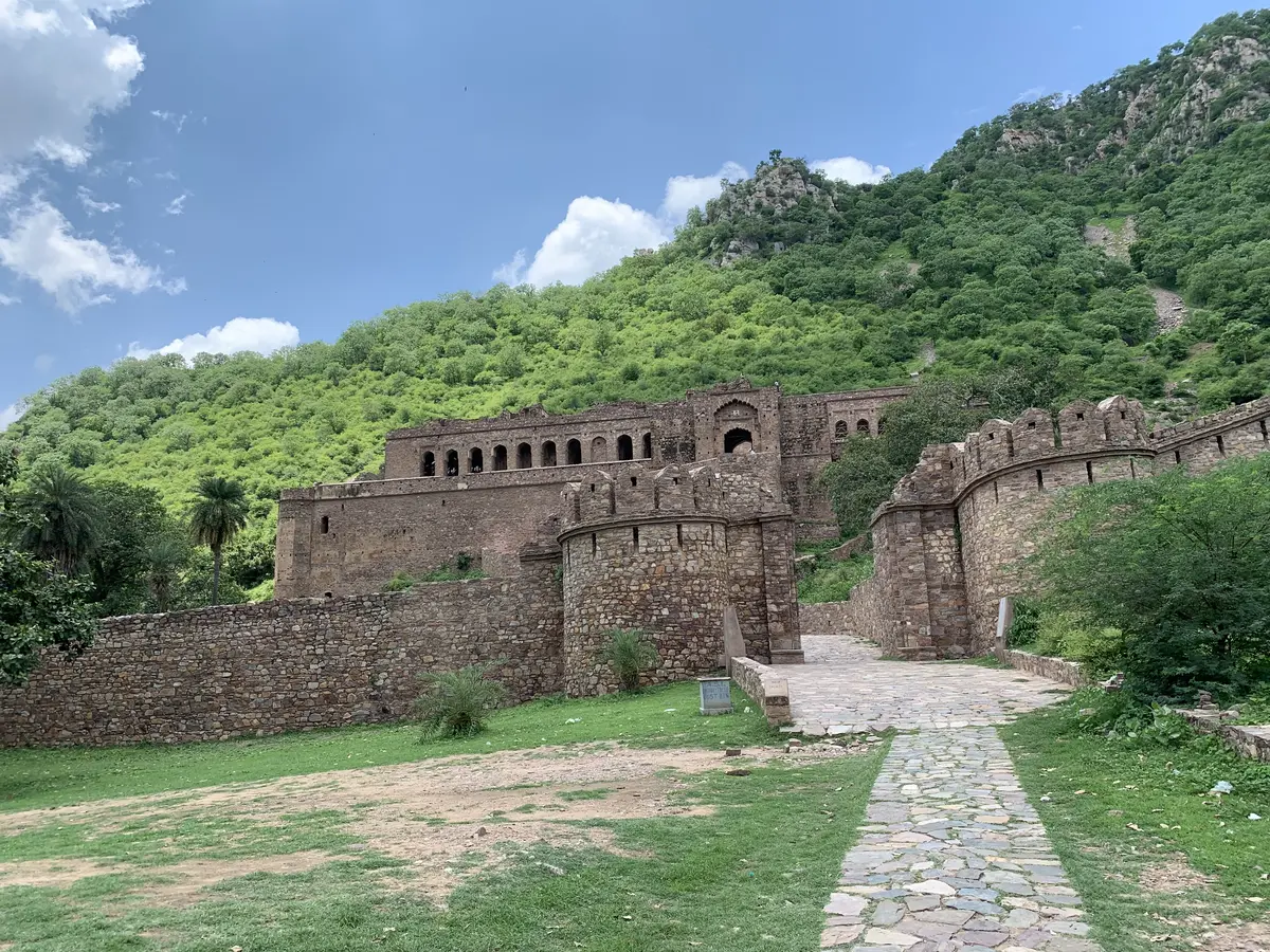
Bhangarh is a ruined city in Rajasthan, at the foot of the Aravalli hills near the Sariska reserve, and it is usually described as the most haunted place in India. What unsettles visitors is the sight of a whole town left standing empty.
The date usually given for its foundation is 1573, when Bhagwant Das, ruler of Amber, built it as the residence of his second son Madho Singh — younger brother of Man Singh, one of the Mughal empire's greatest generals; Thomas Cook and The Dark Atlas both use that year. Rajasthan Tourism's official page says instead that the fort was built in the seventeenth century. The official Alwar district gazetteer dates to about 1599 the moment Madho Singh made Bhangarh the capital of his chiefship; foundation and capital status may not be the same year. Bhangarh was laid out as a walled town of considerable ambition, with markets, temples, havelis and a fortified palace.
The figure repeated everywhere — more than 9,000 houses — is the one Rajasthan Tourism gives, saying the town had them "until 1720"; The Dark Atlas repeats it alongside roughly 10,000 residents. Neither cites a survey, and the 1968 Alwar gazetteer gives no count. What can be seen on the ground is the plan of a town: The Dark Atlas lists five gates (the Lahori, Ajmeri, Phulbari and Delhi gates and the main Ganesh Pol), a bazaar district, residential quarters for nobles and merchants, administrative buildings and a complex of temples.
The decline was not a single event, and the documented sequence is more interesting than the curse. The Rajasthan District Gazetteer of Alwar records that Madho Singh established his chiefship at Bhangarh around 1599 and was succeeded in turn by Shatrushal, Ajab Singh, Hathi Singh, Kabuli Singh and Jaswant Singh. In about 1635 Ajab Singh founded Ajabgarh, and his own grandson Jaswant Singh later built a wall across the valley separating the two villages: the centre of gravity was already moving. In 1720 the ruler of Jaipur attacked Bhangarh and absorbed the territory into his kingdom, and the Chalisa famine of 1783 emptied what remained; by 1800, in The Dark Atlas's account, the city was empty. What visitors walk through today is a complete urban plan without its roofs, in which the street grid can still be read house by house.
Two legends explain the abandonment. In one, a tantric named Singhia, in love with the princess Ratnavati, tries to enchant her with a scented oil; she pours it away, it crushes him under a boulder, and he curses the town with his last breath. In the other, the ascetic Balu Nath permits the town's construction on condition that no building's shadow ever falls on his retreat — and when a later ruler raises the palace too high, the curse falls.
Timeline: the documented record of Bhangarh Fort
- 1573 Bhagwant Das, ruler of Amber, founds Bhangarh as the residence of his second son Madho Singh, younger brother of the Mughal general Man Singh. It is a planned settlement, not a military post.
- c. 1599 The Alwar district gazetteer dates Madho Singh's establishment of his chiefship at Bhangarh here, making the town his capital. He is succeeded by Shatrushal, Ajab Singh, Hathi Singh, Kabuli Singh and Jaswant Singh.
- c. 1635 Ajab Singh, Madho Singh's grandson, founds Ajabgarh. His own grandson Jaswant Singh will later wall off the valley separating the two villages. The centre of power starts moving away from Bhangarh almost a century before the annexation.
- 1720 The ruler of Jaipur attacks Bhangarh and absorbs the territory into his kingdom (Samvat 1777 in the gazetteer). The town stops being anyone's capital and the population begins a sustained decline.
- 1783 The Chalisa famine, the result of a devastating drought sweeping Rajasthan. The Dark Atlas writes that the remaining population of Bhangarh scattered and that the city was empty by 1800; other explanations in circulation point to Mughal aggression or political instability.
- Present day The Archaeological Survey of India prohibits access before sunrise and after sunset by signboard. The press attributes the restriction to safety and preservation, with the Sariska tiger reserve close by.
Is there a rational explanation for Bhangarh Fort?
Two curses explain the ruin, The Dark Atlas writes, and "neither matches the historical record".
The Alwar district gazetteer (1968) records that Ajab Singh, Madho Singh's grandson, founded Ajabgarh in about 1635, and that in 1720 Sawai Man Singh of Jaipur "attacked Bhangarh, and incorporated the territory in his kingdom". Rajasthan Tourism, the state government's tourism department, says the town had more than 9,000 houses until 1720, "after which it gradually diminished in population". The Dark Atlas (2025) adds the last stage, the famine of 1783 remembered as the Chalisa famine: by 1783 "a devastating famine struck the Alwar region, and the remaining population scattered", and by 1800 the city was empty. Thomas Cook's travel blog, which says there is "little definitive evidence of what led to the fort's downfall", sums up the explanations in circulation: "Some point to a famine or drought, others to Mughal aggression, and a few speculate internal betrayal or political instability."
The Dark Atlas notes that every house in the town is a roofless shell while the temples keep their roofs, which is the contrast the curse is said to explain. Its explanation is constructional: the temples were built with heavier stone, vaulted construction and thicker walls, while "residential buildings used lighter roofing materials — timber, thatch, lime plaster — that deteriorated over centuries of exposure".
The most visible piece of the case is the signboard of the Archaeological Survey of India at the gate. As transcribed by The Dark Atlas, it reads: "Entering the borders of Bhangarh before sunrise and after sunset is strictly prohibited. Legal action would be taken against anybody who does not follow this instruction." The notice gives no reason. Boldsky (2026) puts the restriction down to "safety and preservation": the fort sits close to the Sariska Tiger Reserve, "meaning the area can have wildlife movement after dark", and it is "an unlit, fragile heritage site with uneven terrain". The Dark Atlas argues that the sign's silence, "more than any legend, … has made Bhangarh the most famous haunted site in India".
The same site reads the curses of Singhia and Balu Nath as later additions: "The curses came later, invented to explain a silence that history alone could not fill." Both legends supply what a famine or an annexation does not, someone to blame and an intention behind the loss.
Can you visit Bhangarh Fort?
Bhangarh is a ruined town in the Alwar district of Rajasthan. The Ministry of Tourism's Incredible India entry places it approximately midway between Jaipur and Alwar and about 50 km from the Sariska Wildlife Sanctuary. The nearest railway station is Alwar Junction (AWR); the nearest airports are Jaipur (JAI) and Delhi (DEL). Descriptions of the fort as standing on the edge of the Sariska tiger reserve are common, and that 50 km is the figure the ministry publishes.
The same page, consulted on 9 September 2026, gives the opening time as 09:00 and the closing time as 17:00, and states that "Access to the fort is restricted before sunrise and after sunset". The Archaeological Survey of India's notice at the entrance carries the same prohibition together with a ban on staying overnight, and there are guards on the site.
The ground covers a town rather than a keep. The main axis runs in from the gate between the rows of bazaar shops, past the Someshwar, Gopinath and Mangla Devi temples, and rises to the palace at the far end against the hillside. Walked in that order the site reads as a planned settlement rather than an isolated stronghold.
The walk over the whole site takes two to three hours at an unhurried pace. The surface underfoot is loose stone. There is little shade inside the walls, and the midday heat in Rajasthan between April and June is severe. Macaques live on the site and take food that is carried in the open.
Sources consulted
- Rajasthan Tourism, «Bhangarh Fort — información oficial del monumento» — Gobierno de Rajastán, 2026 archive
- Clara M., «Bhangarh Fort: India's most haunted fort and its two curses — el apogeo de más de 9.000 casas y el declive gradual hasta el abandono» — The Dark Atlas, 2025 web
- Thomas Cook India, «Bhangarh Fort ghost stories: facts behind the haunted legends — las teorías sobre el abandono: hambruna o sequía, agresión mogola, traición interna» — Blog de viajes de Thomas Cook India (operador turístico), 2024 web
- Boldsky, «India's 'haunted' Bhangarh Fort has a night entry ban, but is it really about ghosts?» — Boldsky, 2026 newspaper archive
- Incredible India, «Bhangarh Fort — Explore the Bhangarh Fort in Alwar» — Ministerio de Turismo de la India, 2026 archive
- Government of Rajasthan, «Rajasthan District Gazetteers: Alwar — el señorío de Madho Singh en Bhangarh (h. 1599), su línea sucesoria, la fundación de Ajabgarh (h. 1635) y la anexión por Jaipur (1720)» — Rajasthan District Gazetteers, 1968 book
Reviewed by V. Serrano on 2026-07-28 · How we verify our content
💬 Field testimonies (0)
No testimonies yet. Add the first.
Add your testimony
🔒 Log in to add a testimony