👻 HAUNTED PLACE · EXP. Nº9475
ACTIVE
Aokigahara
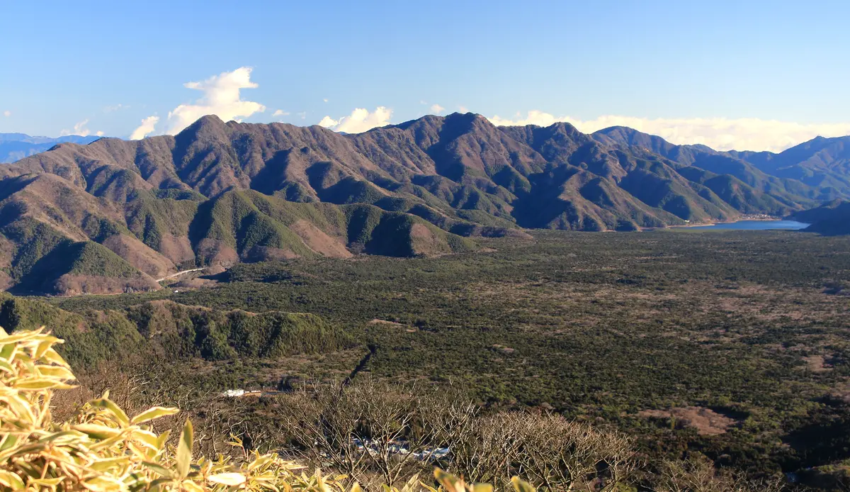
Aokigahara is a forest of roughly 30 square kilometres on the north-western flank of Mount Fuji, between about 900 and 1,300 metres, straddling the village of Narusawa and the town of Fujikawaguchiko in Yamanashi Prefecture.
Where is Aokigahara?
- Location
- Yamanashi, Japan
- Type
- Forest / nature
- Coordinates
- 35.47, 138.62
- Last updated
LOCATION
Why is Aokigahara said to be haunted?
It grew on the Aokigahara lava flow, erupted from a fissure on that flank between 864 and 866 CE, which reached Lake Motosu and split an older lake into the two now called Shoji and Sai. It is not the volcano's last eruption: that was Hoei, in 1707. The soil is barely there, leaf litter and humus over bare lava, and the canopy is dominated by hinoki cypress and Tsuga sieboldii rather than the deciduous trees the climate would predict, which is where the name Jukai, sea of trees, comes from. Despite the label primeval, the forest has been worked: the average hinoki is about 113 years old, hinoki was felled here from the Edo period into early Meiji, and charcoal kilns have been found among the trees. Aokigahara is prefectural forest and the strictest class of protected zone in Fuji-Hakone-Izu National Park; leaving the marked boardwalks is prohibited. Since 2008 the municipalities, the prefecture and local businesses have run a daily outreach and support programme in the forest.
What is the history of Aokigahara?
Aokigahara begins as an accident of drainage. In June of the year 864 a fissure 5.7 km long opened on the north-western flank of Mount Fuji and went on erupting for more than two years. The Japan Meteorological Agency's chronology of Fuji's historical activity records the outcome flatly: lava flowed from near Nagaoyama, the arm running north-west reached Lake Motosu and split the old lake called Se-no-umi into the two now named Shōji and Sai, and houses were buried. The Geological Survey of Japan puts the Jōgan eruption at AD 864–866 and gives its output as roughly 1.3–1.5 km³ of magma.
What grew back sits on that rock and behaves accordingly. Yamanashi Prefecture's own eco-tour guideline defines the area as "roughly 30 square kilometres of so-called primeval forest spreading over the Aokigahara lava flow", between about 900 and 1,300 m, straddling the village of Narusawa and the town of Fujikawaguchiko. A permanent study plot run by ecologists from Ibaraki University found the soil almost nonexistent — leaf litter and humus over bare lava, with almost no horizon structure — and the canopy dominated not by the deciduous trees the regional climate should produce but by hinoki cypress (Chamaecyparis obtusa), 45.4 % of basal area, and Tsuga sieboldii, 26.3 %.
Which brings up the thing least often said about Aokigahara: it is not untouched. The same study cites Kiyofuji's 1991 age survey, in which the oldest hinoki was about 240 years and the average only 113, and historical documents showing hinoki were felled here from the Edo period into early Meiji. Tsuga, useless as timber, was mostly left — which is why tsuga over 300 years old survive and hinoki does not. And the remains of charcoal kilns have been found inside the forest: broadleaves were burnt to charcoal on the spot and carried out, a use that continued widely until recent decades. The two municipalities put it in one line of their own handbook: "in the past it was a forest that supported the lives of local people."
Nor is it national forest, as is usually assumed: Aokigahara is Yamanashi prefectural forest, part of the onshirin estate granted to the prefecture in 1911, and it heads the Ministry of the Environment's table of Special Protection Zones for Fuji-Hakone-Izu National Park at 1,225 hectares, every parcel publicly owned. It had been a National Natural Monument since February 1926, well before the park itself.
The dark reputation is the newest layer, and the one where the sources stop agreeing. It is routinely traced to a Seichō Matsumoto novel, but two different novels get the credit and neither attribution survives the record. Nami no Tō ("Tower of Waves") was serialised in Josei Jishin and published by Kobunsha in 1960, the year under which the National Diet Library catalogue holds that edition. Kuroi Jukai — literally "black sea of trees", which is presumably why it gets swept in — was published by Kodansha, also in 1960, and Kodansha's own synopsis places it at a bus crash near Hamamatsu and inside a newspaper office. It has nothing to do with Fuji. Bungeishunju's current edition of Nami no Tō summarises the plot as a doomed affair between a young prosecutor and the wife of a man implicated in a ministry corruption case, and never mentions the forest.
Against that, the two local governments date the change themselves, and not to 1960. Their handbook says the forest "became famous as a place of suicide from the Shōwa 40s" — that is, 1965–1974, a decade or more after either book. By 1988 a psychiatrist at Yamanashi Medical College, Yoshitomo Takahashi, could open a paper in Suicide and Life-Threatening Behavior by stating the association as established background. In July 1993 Ohta Books published Wataru Tsurumi's Kanzen Jisatsu Manyuaru, 198 pages, still advertised by the publisher in its own words as "a suicide device made of words"; between 1999 and 2023 at least five prefectures — Kanagawa first, on 22 October 1999 — designated it a publication harmful to young people.
What is documented in detail is the response. In June 2008 the municipalities, local businesses and the prefecture formed the Inochi wo Tsunagu Aokigahara Network Conference, chaired by the mayor of Fujikawaguchiko. Its outreach programme, catalogued by Japan's national suicide-prevention centre, puts two teams of two paid staff on patrol every day of the year, roughly 09:00 to 17:00, around the caves, car parks and boardwalks, backed by shopkeepers, the bus and taxi companies, a drug-rehabilitation NPO on night rounds, a police box in the summer holidays and, since FY2024, drones after dark. The published results are counted in people helped: 346 approached and 48 taken into protection in FY2020; 2,359 approached and 525 taken into protection between FY2012 and FY2019 — at zero cost to the municipalities.
The other half of the answer is about narrative. Yamanashi's Third Suicide Prevention Plan (2024–2028) commits two named departments in writing: forestry policy "will dispel the image of a 'famous suicide spot', including by not permitting the use of prefectural land such as Aokigahara Jukai for the filming of films or television programmes that risk encouraging suicide", and tourism confirms the prefectural film commission will not support such shoots. The prefecture's own 2025 booklet is titled The Truth About Aokigahara Jukai: moss, lava caves, guides and food, in which the word "suicide" does not appear once.
Timeline: the documented record of Aokigahara
- 864–866 — the Jōgan eruption A fissure 5.7 km long opens on Mount Fuji's north-western flank and erupts for more than two years. Lava from near Nagaoyama reaches Lake Motosu, splits the old lake Se-no-umi into Shōji and Sai, buries houses and kills the lake's fish. Total output is estimated at roughly 1.3 to 1.5 km3 of magma.
- 1911 — the forest changes hands The imperial forest estate is granted to Yamanashi Prefecture and becomes the onshirin, some 158,000 hectares covering about 35 % of the prefecture. Aokigahara is prefectural forest, not national forest, and entry permits are issued by the prefecture to this day.
- 24 February 1926 The forest is designated a National Natural Monument. The lava caves and lava tree moulds of the same flow follow on 17 December 1929. The state's interest in this place was geological and botanical long before it was anything else.
- 1 February 1936 Fuji-Hakone National Park is designated, later renamed Fuji-Hakone-Izu. Aokigahara is listed first in the park's table of Special Protection Zones, 1,225 hectares, every parcel of it publicly owned, with a contiguous Class-1 Special Zone of 1,311 hectares alongside.
- 1943 — the lava that founded a discipline Takesi Nagata publishes his rock-magnetism study of the Aokigahara lava, showing that a lava's magnetisation survives sampling and can be read as a record of the ancient geomagnetic field. A later Shizuoka University report calls it the moment the curtain rose on modern palaeomagnetism.
- 1960 — the two novels Both novels routinely blamed for the forest's reputation are published this year, not in 1961: Nami no To by Kobunsha and Kuroi Jukai by Kodansha. Kodansha's own synopsis places Kuroi Jukai at a bus crash near Hamamatsu, with no connection to Mount Fuji.
- The Showa 40s (1965-1974) The two municipalities that contain the forest date the change themselves, in their own handbook: in the past it was a forest that supported the lives of local people, but from the Showa 40s it became famous as a place of suicide. That is a decade or more after either novel.
- 1988 Yoshitomo Takahashi, a psychiatrist at Yamanashi Medical College, opens a paper in Suicide and Life-Threatening Behavior by stating the association as established background.
- July 1993 Ohta Books publishes Wataru Tsurumi's Kanzen Jisatsu Manyuaru, 198 pages, advertised by the publisher in its own words as a suicide device made of words.
- 22 October 1999 Kanagawa Prefecture formally designates the book a publication harmful to young people. It is the earliest such designation traceable in an official record; at least five prefectures did the same between 1999 and 2023.
- June 2008 The surrounding municipalities, local businesses and the prefecture form the Aokigahara Network Conference, chaired by the mayor of Fujikawaguchiko. Its outreach programme puts two teams of two on patrol every day of the year and reports 2,359 people approached and 525 taken into protection between FY2012 and FY2019.
- July 2013 to April 2014 The Yamanashi Nichinichi Shimbun runs 43 instalments in seven parts on the forest. Its desk chief describes the aim as overwriting the prevailing image with that of a beautiful and powerful forest of life.
- 2024-2028 Yamanashi's Third Suicide Prevention Plan commits the forestry division to refusing the use of prefectural land such as Aokigahara for filming that risks encouraging suicide, and the tourism division to withholding film-commission support. The same plan records that about 30 % of the people found in the prefecture lived elsewhere, and sets a target for reducing that number.
Is there a rational explanation for Aokigahara?
Four common assertions about Aokigahara are taken in turn below, followed by a note on this page.
"Compasses don't work in Aokigahara." Two official documents that describe the forest in detail say nothing of the kind. The explanatory notes to the Geological Survey of Japan's 2016 geological map of Fuji describe the Aokigahara lava and the fissure that fed it without once using the character 磁, "magnetism". Yamanashi Prefecture's 2025 booklet The Truth About Aokigahara Jukai names the forest nineteen times, and the character for "magnetism" does not occur in it once.
There is a real fact underneath, and it is better than the legend. Rock magnetism on Fuji is genuinely strong and stable — so much so that Takesi Nagata used the Aokigahara lava in 1943 to show that a lava's magnetisation survives sampling and can be read as a record of the ancient geomagnetic field, a paper a 1997 Shizuoka University report calls the moment "the curtain rose on modern palaeomagnetism". The same report describes what that means in the field: some Fuji lavas are magnetised strongly enough to disturb a bearing taken with a clinometer, so the geologists ran kite string out to a point well clear of the rock and used the distant reading whenever the near one was affected. That is the whole phenomenon. An instrument resting on magnetised basalt reads the basalt; held well away from the rock, it reads the Earth's field. People do get lost here — but the prefecture's own explanation is a lava floor pitted with holes hidden under fallen leaves, which is why stepping off the boardwalk is prohibited outright.
"An untouched primeval forest." The tourist literature says genseirin; the ecology says otherwise. Age surveys found the oldest hinoki about 240 years old and the mean only 113, documents record hinoki cut from Edo into early Meiji, and charcoal kilns have been found among the trees. The ecologists suggest this human disturbance is part of why oak is scarce and conifers dominate a site whose climate should produce deciduous forest. Aokigahara is about 1,160 years old as a lava surface and rather less than 250 in most of its standing timber.
"A 1961 novel made it the suicide forest." The bibliography settles the first half: both candidate novels appeared in 1960, Nami no Tō from Kobunsha and Kuroi Jukai from Kodansha, and Kodansha's own synopsis sets Kuroi Jukai around a bus crash near Hamamatsu, with no connection to Fuji; its title is presumably what drags it in. The larger problem is the date of the reputation itself. The two municipalities that contain the forest say in their own handbook that it became known as a place of suicide "from the Shōwa 40s", 1965–1974 — a decade or more after either book. The World Health Organization's guidance for reporters says "Don't oversimplify the reason for a suicide or reduce it to a single factor", and the single-novel story also fails on the calendar. What can be said is narrower: by 1988 the association was established enough for a Yamanashi psychiatrist to state it as background in a peer-reviewed journal.
The figures. Japan counts suicides two ways, and Yamanashi's own plan sets out the difference: the National Police Agency's statistics record a death where the body was found, the Ministry of Health, Labour and Welfare's vital statistics where the person lived. For Yamanashi the two give very different results. On the residence basis the prefecture's 2022 rate per 100,000 was 16.8; on the discovery basis it was 24.8, the highest in Japan. The prefecture's own plan explains the gap without euphemism: in 2022, of the people found in Yamanashi, 137 lived there and 62 — about 30 % — came from outside or could not be identified. Yamanashi consequently sets two separate targets, one of which is to reduce the number of people who cross a prefectural boundary to die inside it. The plan gives its figures for the prefecture and for its health regions, and notes that the gap between the two bases is most marked in Fuji-Tōbu, the region that contains the forest. It names Aokigahara only in its list of measures, among them police patrols, a mobile police box and the refusal of filming on prefectural land, and gives no figure for the forest itself.
And a note on what this page does. The WHO's 2023 quick reference guide for media professionals lists among its Don'ts "Don't name or provide details about the site/location", "Don't describe the method used" and "Don't use photographs, video footage, audio recordings, or digital or social media links", and among its Dos "Do provide accurate information about where and how to seek help for suicidal thoughts and suicidal crises". An entry about a named place cannot honour the first and remain an entry about that place. It can honour the rest — which is why this file prints no method, no death count for the forest and no personal case.
Can you visit Aokigahara?
Aokigahara is public forest and visiting it is an ordinary thing to do. It is also the first entry in the Special Protection Zone table of Fuji-Hakone-Izu National Park — 1,225 hectares, wholly public land, alongside a contiguous 1,311-hectare Class-1 zone — and a National Natural Monument, so the rules are firmer than for most walks. The park was designated on 1 February 1936.
The rule about routes is a prohibition with its reasons printed beside it. The prefecture's own visitor booklet gives two reasons in one sentence: "there is a danger of catching your foot in lava holes hidden by fallen leaves and falling", and "from the standpoint of environmental protection, leaving the trail and entering is prohibited". The official eco-tour guideline, in force since 2004, tells participants to "never leave the routes designated in these guidelines" and then names them: the Shōji-guchi trail, the maintained boardwalks including the Tōkai Nature Trail, and the forest roads. It caps groups at 20-25 people with about one guide per ten, asks walkers to go single file, and bans marking trees with tape or paint outright. Anything beyond those routes requires a permit from the prefecture's Fuji-Tōbu forestry office. Also posted: no fires, no collecting plants, no damage to moss or rock.
The two show caves are lava tubes of the same flow, and their operator published all of this on 22 September 2026. Fugaku Wind Cave runs 201 m with a ceiling up to 8.7 m, averages 3 °C, and takes about fifteen minutes to walk; its basalt walls absorb sound, so the interior does not echo. Narusawa Ice Cave runs 153 m, is 1.5 to 11 m wide and 1 to 3.6 m high, averages the same 3 °C, and loops, so the circuit closes on itself in six or seven minutes. Admission at both is ¥350 for adults and ¥200 for children of primary-school age and under, dropping to ¥250 and ¥100 for groups of fifteen or more, with school rates of ¥200 for secondary pupils and ¥100 for primary. Opening is at 9:00 all year; closing moves in six steps — 17:30 from 1 August to 15 October, 17:00 to 15 November, 16:30 to 15 February, 16:00 to 28 February, 16:30 to 15 March, 17:00 to 31 July — under the operator's own caveat that hours change with the weather and the state of the caves. Car parks hold 150 cars and 10 coaches at the wind cave, 100 and 10 at the ice cave. The ice cave sits at the eastern entrance of Aokigahara and was declared a natural monument by the Ministry of Education in 1929; the wind cave stored silkworm eggs as a natural refrigerator until the early Shōwa years. Addresses and telephones are published: 〒401-0332 Yamanashi, Minamitsuru-gun, Fujikawaguchiko-machi, Saiko Aokigahara 2068-1, 0555-85-2300; and 〒401-0320 Yamanashi, Minamitsuru-gun, Narusawa-mura 8533, 0555-85-2301.
Getting there is thirty minutes by local bus from Kawaguchiko Station, alighting at the Fūketsu or Hyōketsu stops, or twenty minutes by car from the Kawaguchiko interchange on the Chūō Expressway. A two-day Retro Bus pass covers the Kawaguchiko and Saiko-Aokigahara loops.
A point of World Heritage bookkeeping: Mount Fuji was inscribed in 2013 with 25 constituent assets, and the two famous caves are not among them. What is inscribed nearby are the three lakes this flow made or bounded — Sai, Shōji and Motosu, assets 1-7 to 1-9 — and the Funatsu and Yoshida lava tree moulds, assets 21 and 22.
One activity is refused outright. Yamanashi Prefecture does not permit entry for the purpose of filming films, television programmes or streamed video that risk encouraging suicide, and the prefectural film commission will not support such shoots on prefectural land. That is standing written policy, published in the local network conference's handbook and restated in the prefectural plan for 2024-2028.
The forest is also worked, every day, by people whose job is to talk to whoever seems to need it. The Aokigahara ふれあい声かけ事業 puts two pairs of dedicated municipal staff on patrol by car and on foot, roughly 09:00 to 17:00, on a 365-day rota across Narusawa and Fujikawaguchiko; nearby shops pass on what they notice. The published results: 346 people approached and 48 protected in the 2020 financial year, and 2,359 approached and 525 protected across 2012 to 2019. The programme costs the two municipalities nothing, being carried by the national grant for local suicide countermeasures, and its contacts are printed in the case file: Narusawa's welfare and health section on 0555-85-3081, Fujikawaguchiko's welfare promotion section on 0555-72-6028. The network conference behind it was founded in June 2008 and is chaired by the mayor of Fujikawaguchiko.
The lines those teams hand out, together with the Spanish one, were checked against their operators' own pages on 22 September 2026.
Spain — 024. The Ministry of Health describes it as "un servicio de alcance nacional (accesible desde todo el territorio nacional), gratuito, confidencial y disponible las 24 horas del día, los 365 días del año", whose users are "las personas con conducta o ideación suicida, así como los familiares o allegados de víctimas de suicidio o de personas con ideación suicida". There is an online chat run with the Red Cross and access in sign language by video interpretation.
Japan — #いのちSOS, 0120-061-338, listed by the Ministry of Health, Labour and Welfare as free and open 24 hours, 365 days. The same ministry lists the Kokoro no Kenkō Sōdan Tōitsu Daiyaru on 0570-064-556, whose hours vary by prefecture and which carries a call charge.
Japan, in English — TELL Lifeline, 0800-300-8355, toll free. TELL puts it plainly: "Whoever you are, whatever you are going through, if you are living in Japan our trained Lifeline Support Workers are here for you." Phone hours run continuously from Saturday 09:00 to Monday 23:00, then 09:00-23:00 Tuesday to Thursday and 09:00-02:00 on Friday; the chat service opens daily at 16:00.
Sources consulted
- いのちをつなぐ青木ヶ原ネットワーク会議 / 山梨県富士・東部保健福祉事務所, «自殺に傾く人への対応手引き ― 青木ヶ原樹海周辺で気になる方に出会ったら ― (第5版) — the local network's own handbook: legal status of the forest, the ban on filming that risks encouraging suicide, the outreach teams, and the two municipalities' statement that the forest became known as a place of suicide 'from the Shōwa 40s'» — Aokigahara Network Conference & Yamanashi Prefecture Fuji-Tōbu Health and Welfare Office, 2025 report
- 山梨県, «第3期山梨県自殺対策推進計画(2024〜2028年度)— the residence-basis and discovery-basis rates, the ~30 % of people found in the prefecture who lived elsewhere, and the written commitments of the forestry and tourism divisions on filming and on dispelling the 'famous suicide spot' image» — Yamanashi Prefectural Government, 2024 report
- いのち支える自殺対策推進センター (JSCP), «青木ヶ原ふれあい声かけ事業(山梨県鳴沢村・富士河口湖町), 自殺対策先進事例データベース — the outreach programme in detail: two two-person teams, 365 days, 09:00–17:00, and the published results (346 approached / 48 protected in FY2020; 2,359 / 525 across FY2012–FY2019)» — Japan Suicide Countermeasures Promotion Centre, MHLW-designated body, 2021 report
- 環境庁 (now 環境省), «富士箱根伊豆国立公園 富士山地域 指定書及び公園計画書 — Aokigahara as the first entry in the Special Protection Zone table (1,225 ha, wholly public land), the contiguous 1,311 ha Class-1 zone, the park's designation on 1 February 1936 and the natural-monument designation dates» — Ministry of the Environment of Japan, 1996 report
- 大塚俊之・横澤隆夫・大竹勝 (Toshiyuki Ohtsuka, Takao Yokosawa, Masaru Ohtake), «富士北麓青木ヶ原溶岩流上における針葉樹林の構造と動態 (Community structure and dynamics of coniferous forest on Aokigahara lava flow, Mt. Fuji), 植生学会誌 25(2): 95-107 — hinoki 45.4 % and Tsuga sieboldii 26.3 % of basal area, undeveloped soil, Kiyofuji's tree ages (max 240 yr, mean 113), Edo-to-Meiji logging and the charcoal kilns found inside the forest» — Vegetation Science (植生学会誌), The Society of Vegetation Science, 2008 academic
- 新妻信明 (Nobuaki Niitsuma), «富士山の地質と新富士溶岩の古地磁気 (Geology of Mt. Fuji and palaeomagnetism of lavas of Shin-Fuji Volcano), 静岡大学地球科学研究報告 24: 27-41 — Nagata's 1943 study of the Aokigahara lava as the opening of modern palaeomagnetism, and the field method used because some Fuji lavas disturb a clinometer bearing» — Geoscience Reports of Shizuoka University, 1997 academic
- 高田亮・山元孝広・石塚吉浩・中野俊, «富士火山地質図(第2版)説明書 / Geological Map of Fuji Volcano, 2nd edition, explanatory notes — the Jōgan eruption of AD 864–866, the Aokigahara lava (unit Sd-Aog), the fissure vents from Kōriana down to Kudariyama spanning 5.7 km, and erupted volumes of roughly 1.3–1.5 km³» — 産業技術総合研究所 地質調査総合センター (Geological Survey of Japan, AIST), 2016 report
- 気象庁 (Japan Meteorological Agency), «富士山 有史以降の火山活動 — the Jōgan eruption of 864–866: north-western flank, lava from near Nagaoyama (the Aokigahara lava), Lake Se-no-umi split into Shōji and Sai, Lake Motosu reached, houses buried» — Japan Meteorological Agency, volcano database, 2013 report
- Yoshitomo Takahashi, «Aokigahara-jukai: suicide and amnesia in Mt. Fuji's Black Forest, Suicide and Life-Threatening Behavior 18(2): 164-175 (PMID 3420643) — a Yamanashi Medical College psychiatrist recording in 1988 that the association was already established» — Suicide and Life-Threatening Behavior, 1988 academic
- 山梨県観光文化・スポーツ部 / 青木ヶ原樹海魅力再発見事業事務局, «青木ヶ原樹海の真実 〜富士山麓にある、いのちの育み〜 (The Truth About Aokigahara Jukai) — the prefecture's own visitor booklet: the prohibition on leaving the boardwalk, the lava holes hidden by fallen leaves, the helmet recommendation for the caves. Contains no mention of magnetism and no mention of suicide» — Yamanashi Prefectural Government, 2025 report
- 富士山青木ヶ原樹海等エコツアーガイドライン推進協議会, «富士山青木ヶ原樹海等エコツアーガイドライン — the official definition of the area as about 30 km² of forest on the Aokigahara lava flow, the rule never to leave the designated routes (Shōji-guchi trail, maintained boardwalks including the Tōkai Nature Trail, forest roads), group-size and guide ratios, the ban on marking trees, and the prefectural forestry permit» — Yamanashi Prefecture (secretariat: Yamanashi Prefectural Mt. Fuji World Heritage Center), 2009 report
- 鳴沢村役場 企画課, «樹海の里鳴沢村の村勢要覧, 富士学研究 19(1): 60-61 — the village profile: the Jōgan eruption of 864–866 about 10 km north-west of the summit, the forest at 30 km² straddling Narusawa and Fujikawaguchiko, and the village's list of designated cultural properties with their dates» — Journal of Fuji Studies (富士学研究), 2024 report
- World Health Organization, «Preventing suicide: a resource for media professionals — quick reference guide: responsible reporting on suicide (update 2023) — the Dos and Don'ts applied throughout this file» — World Health Organization (WHO/UCN/MSD/MHE/2023.5), 2023 report
- 松本清張 (Seichō Matsumoto), «黒い樹海 — the publisher's own synopsis, which places the novel at a bus crash near Hamamatsu and inside a newspaper office, with no reference to Mount Fuji or Aokigahara» — 講談社 (Kodansha), 1960 web
- 松本清張 (Seichō Matsumoto), «長編小説 波の塔 — National Diet Library catalogue record for the Kobunsha edition, dated 1960» — 国立国会図書館サーチ / National Diet Library Search, 1960 archive
- 松本清張 (Seichō Matsumoto), «波の塔 下 (新装版) — the current publisher's synopsis of the second volume: a prosecutor, the wife of a man implicated in a ministry corruption case, and no mention of the forest» — 文藝春秋 (Bungeishunju), 文春文庫, 2009 web
- 鶴見済 (Wataru Tsurumi), «完全自殺マニュアル — the publisher's own record: 5 July 1993, 198 pages, ISBN 4872331265, and the publisher's own description of the book. Neither 樹海 nor 青木ヶ原 appears on the page» — 太田出版 (Ohta Books), 1993 web
- 神奈川県 (Kanagawa Prefecture), «有害図書類一覧(個別指定)— the prefecture's official list of individually designated harmful publications, whose first line records 完全自殺マニュアル (太田出版), designated 22 October 1999» — Kanagawa Prefectural Government, 2024 report
- 日本新聞協会, «新たなイメージを上書き, 新聞協会報 (20 May 2014) — the Yamanashi Nichinichi Shimbun's 43-instalment, seven-part series of July 2013 to April 2014 and its stated aim of overwriting the forest's image with 'a beautiful and powerful forest of life'» — Japan Newspaper Publishers & Editors Association, 新聞協会報, 2014 newspaper archive
- 富岳風穴・鳴沢氷穴, «富岳風穴・鳴沢氷穴 — the operator's official pages: cave lengths (201 m and 153 m), average internal temperature about 3 °C, admission ¥350 / ¥200, seasonal opening hours, free parking, bus access from Kawaguchiko Station, and the wind cave's use as a natural refrigerator for storing silkworm eggs until the early Shōwa years» — mtfuji-cave.com (official cave operator), 2026 web
- 山梨県立富士山世界遺産センター, «構成資産・構成要素一覧 — the official list of the 25 constituent assets of the World Heritage property 'Fujisan, sacred place and source of artistic inspiration': lakes Sai, Shōji and Motosu (1-7 to 1-9) and the Funatsu and Yoshida lava tree moulds (21, 22) are inscribed; the Fugaku and Narusawa caves are not» — Yamanashi Prefectural Mt. Fuji World Heritage Center, 2026 web
- 山梨県富士・東部保健福祉事務所, «富士・東部保健所における自殺防止の取り組みについて — the Aokigahara Network Conference founded in June 2008, composed of the surrounding municipalities and local businesses and chaired by the mayor of Fujikawaguchiko» — Yamanashi Prefecture Fuji-Tōbu Health and Welfare Office, 2026 web
- Ministerio de Sanidad, «Línea 024 de atención a la conducta suicida — the Ministry of Health's own description: national, free, confidential, 24 hours a day, 365 days a year, with an online chat» — Gobierno de España, Ministerio de Sanidad, 2026 web
- 厚生労働省 (Ministry of Health, Labour and Welfare), «まもろうよ こころ — 電話相談 — the ministry's own list of consultation lines, including #いのちSOS on 0120-061-338 (free, 24 hours, 365 days) and the Kokoro no Kenkō Sōdan Tōitsu Daiyaru on 0570-064-556» — Ministry of Health, Labour and Welfare of Japan, 2026 web
- TELL Japan, «TELL Lifeline — the operator's own page: 0800-300-8355 toll free, open and free to everyone in Japan who speaks English, with phone hours and a daily chat service from 16:00» — telljp.com, 2026 web
- 山梨県, «山梨の県有林 — the prefecture's own account of its forest estate: the onshirin granted in 1911, 158,000 ha covering about 35 % of the prefecture, and Aokigahara among the natural forests designated national natural monuments» — Yamanashi Prefectural Government, 2026 web
Reviewed by V. Serrano on 2026-08-01 · How we verify our content
💬 Field testimonies (0)
No testimonies yet. Add the first.
Add your testimony
🔒 Log in to add a testimony