👻 HAUNTED PLACE · EXP. Nº9474
ACTIVE
Devil's Sea
The Devil's Sea is a stretch of Pacific south of Japan that got its English name on 16 January 1955, when The New York Times printed a Reuters cable about nine ships lost there in five years.
Where is Devil's Sea?
- Location
- Japan
- Type
- Other
- Coordinates
- 31.92, 140.02
- Last updated
LOCATION
Why is Devil's Sea said to be haunted?
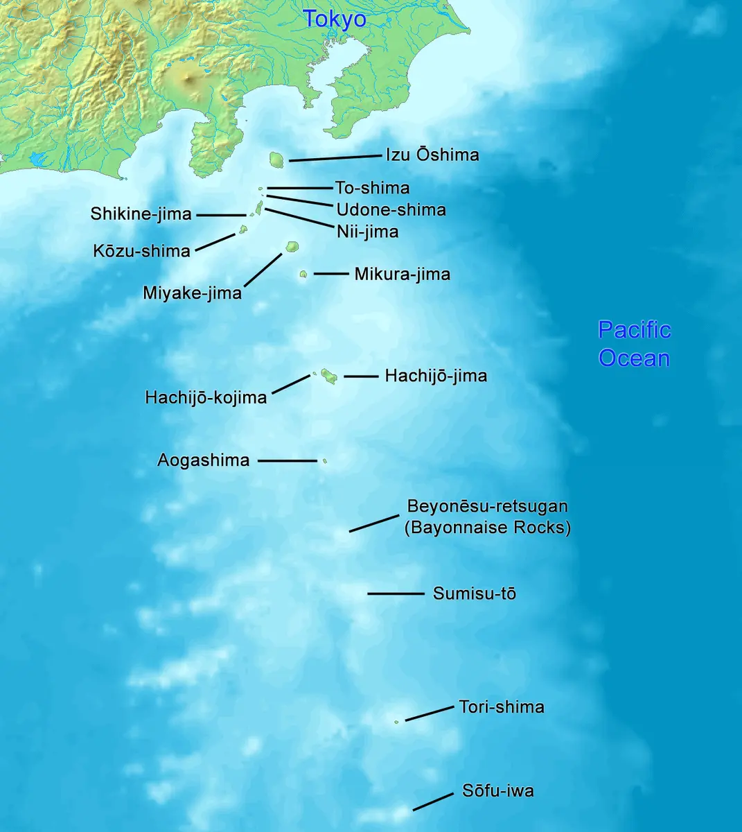
The cable had been filed to report that the latest missing vessel was safe: her radio had broken and she had gone on fishing. The Japanese story behind it, in the Yomiuri Shimbun two days earlier, listed the same nine losses and explained the largest of them. The survey ship Kaiyo Maru No. 5 was destroyed on 24 September 1952 with twenty-two crew and nine scientists aboard, while charting the erupting submarine volcano Myojin-sho; US Navy hydrophones 8,600 km away in California and a tsunami gauge on Hachijojima timed the explosion to about 12:20 that day. The other eight were fishing boats of 62 to 190 tons, lost across 1,200 km of ocean in a country too poor to fit them all with radios. The name Dragon's Triangle appears no earlier than the title of a Charles Berlitz book published in 1989.
What is the history of Devil's Sea?
The Devil's Sea has a birth certificate, and it is a wire story about a ship that came home.
On 16 January 1955, on page 8 of section S, The New York Times printed a short Reuters cable datelined Tokyo, 15 January, under the headline Tokyo Gets News From Missing Ship — Faint Signal Ends Japanese Fears for Vessel's Fate — All Aboard Are Safe. Its first sentence told readers that a faint radio signal heard in Tokyo that day had informed "fear-stricken Japanese fishermen that the 'devil's sea,' mystery graveyard of nine ships in the last five years, had at last been cheated" of a victim. The vessel in question was the Shinyō Maru No. 10, a 144-ton fisheries patrol boat of the Japanese Fisheries Agency, out of contact since 4 January somewhere south-east of Mikurajima. She was found on the 15th about twenty miles east of Hachijōjima, undamaged. Her radio had failed and she had simply gone on working.
Behind that cable sat a Japanese newspaper story two days older. The Yomiuri Shimbun of 14 January 1955, morning edition, page 7, carried the headline Did the "sea of the devil" swallow the Shinyō Maru? Nine ships in five years vanish, leaving only a riddle. It drew a box of ocean roughly 200 miles east to west and 300 miles north to south, running from the Izu islands out east of the Ogasawara chain, said that nine ships and 215 men had been lost inside it in five years, and reported that the Yokohama office of the Maritime Safety Agency had gone so far as to designate the area a special hazard zone. Then it did something no later English version does: it named the cause of its own headline case. The largest ship on its list, it wrote, was the Maritime Safety Agency Hydrographic Department survey vessel Kaiyō Maru No. 5 — 211 tons, Captain Hamamoto Haruyoshi, thirty-one aboard — which had met a tragic end in September 1952 when it ran into the explosion while surveying Myōjin-shō. Apart from the Kaiyō Maru No. 5, the article added, the causes were unknown.
That exception is the whole story, and it deserves telling properly.
At about 07:15 on 17 September 1952 the Myōjin Maru No. 11, a 115-ton bonito boat out of Yaizu in Shizuoka under Captain Masuda Kinjirō, radioed Yaizu that a submarine volcano was erupting some seventeen nautical miles north-north-east of the Bayonnaise Rocks, the barely exposed rim of a large submerged caldera 420 km south of Tokyo. A bonito boat from Ogasawara, the Takino Maru, had watched the same eruption the previous evening, but her radio was broken and she could tell nobody. The Maritime Safety Agency sent the patrol vessel Shikine, which arrived on the morning of the 18th to find a new island 100 metres by 150 and thirty metres high, still erupting, and that afternoon the agency named the reef Myōjin-shō after the boat that had reported it.
Two scientific parties went out. The Tokyo University of Fisheries sent the Shin'yō Maru (229 tons), which reached the site at 04:00 on 23 September to find the island already gone and only discoloured water and two low rocks. She then sat through three explosions that day — at 08:34, at 13:12 and at 13:40 — the last of them while a professor was leaning over the rail to fish out floating pumice, and got clear at full astern.
The Maritime Safety Agency's Hydrographic Department sent the Kaiyō Maru No. 5, which left Tokyo at 10:15 on 23 September. She had been built at Mitsubishi's Shimonoseki yard in July 1942 as the Imperial Navy hydrographic vessel Daigo Kaiyō, had worked the Kiska evacuation in 1943, and had passed to the new civilian coast guard after the war: 200-odd tons, 34 metres, 11.5 knots. Aboard were Captain Hamamoto and twenty-two crew, plus nine members of a survey party — Tayama Toshirō, head of the survey division and concurrently a professor at Tōhoku University; Nakamiya Mitsutoshi, head of the marine observation division; Kawada Kiyosuke, geologist at the Tokyo University of Education; and among the junior men Mita Ryōichi, twenty-six, who in 1949 had written the first research paper anyone had published on this volcano.
Her last message went out at 20:30 on the 23rd, reporting her 20:00 position at 34°06'N 139°37'E, clear weather, nothing abnormal. At 09:00 on the 24th the Hydrographic Department signalled her to ask for a first report and to warn her that the Shin'yō Maru had seen the island disappear. She did not answer, and she missed the noon schedule. A search was ordered at 09:55 on the 25th. On the 27th at 13:50 the patrol boat Kōzu recovered a current-measuring buoy stencilled with the agency's mark; at 16:40 the Shikine picked up a life ring painted over in white, and when the paint was scraped off it read No.5 KAIYO-MARU TOKYO. Timber from the wreck had millimetre-sized volcanic fragments driven into it, and the rock matched Myōjin-shō. The search was called off on 11 October. No bodies were ever recovered.
The country took it hard. Suda Kanji, then head of the Hydrographic Department, later wrote that the loss was picked as one of the ten news stories of 1952. A joint memorial service for all thirty-one was held at Tsukiji Hongan-ji in Tokyo on 28 October, the altar carrying their portraits between some two hundred wreaths, including one from the Emperor and Empress; all thirty-one were decorated on 22 January 1953. Kawada was awarded a posthumous doctorate for a chapter of the thesis he had almost finished. His widow, Kawada Natsue, founded a bulletin called Gokaiyō in 1955 and edited it for twenty-one issues; families kept meeting on the anniversary, in a room built for the purpose on the Hydrographic Department's grounds, until the thirty-third.
The English legend arrived later and from outside. Ivan T. Sanderson's Invisible Residents (World Publishing, 1970) placed one of his global "vortices" in the sea south of Japan. Charles Berlitz carried the Devil's Sea into the mass market in The Bermuda Triangle (1974), and in 1989 Wynwood Press published his The Dragon's Triangle, which is the earliest use of that name this review has been able to date.
Timeline: the documented record of Devil's Sea
- 1869 The Japan Coast Guard's volcano file records the first submarine eruption known at the Bayonnaise Rocks. Ten more follow before 1970; the Smithsonian's database lists twenty-five eruptive episodes here since this date.
- February–December 1946 An island appears and vanishes over ten months: 200 by 150 metres in February, four separate islets about 36 metres high in April, one of them 100 metres high in October, all of it below the surface again by December.
- 17 September 1952 The bonito boat Myōjin Maru No. 11, out of Yaizu, radios an eruption at 07:15 north-north-east of the Bayonnaise Rocks. The Maritime Safety Agency names the new reef after her the next afternoon. Another boat had seen it the evening before but her radio was broken.
- 23 September 1952 The Tokyo University of Fisheries ship Shin'yō Maru finds the island already gone and witnesses three explosions in one day, the last at 13:40 while a professor leans over the rail for pumice. The Kaiyō Maru No. 5 leaves Tokyo at 10:15 and signals for the last time at 20:30.
- 24 September 1952 At about 12:20 Japan time a large eruption destroys the Kaiyō Maru No. 5. Twenty-two crew and nine scientists die. Hydrophones in California and a tsunami gauge on Hachijōjima time the explosion independently.
- 27 September 1952 The patrol boat Kōzu recovers a marked buoy at 13:50; at 16:40 the Shikine picks up a life ring painted white which, scraped, reads No.5 KAIYO-MARU TOKYO. Wreck timber is studded with volcanic fragments matching Myōjin-shō.
- 22 December 1952 The board of inquiry chaired by the agency's commandant Yanagisawa Yonekichi concludes that the ship was struck by a submarine volcanic explosion from below and to starboard, that her upper works on that side were largely destroyed, and that she capsized and sank at once.
- 1953 Robert S. Dietz and M. J. Sheehy publish the Sofar reconstruction: over a hundred explosions logged 8,600 km away in California, and the loss of the ship and all thirty-one aboard timed to about 12:20 on 24 September.
- 4–15 January 1955 The 144-ton fisheries patrol boat Shinyō Maru No. 10 goes off the air south-east of Mikurajima and is found safe east of Hachijōjima eleven days later. Her radio had broken.
- 14 January 1955 The Yomiuri Shimbun, page 7, groups nine losses and 215 dead into a single box of ocean and reports fishermen calling it ma no umi. It also states that the Kaiyō Maru No. 5 died in the Myōjin-shō eruption — the detail every later version drops.
- 16 January 1955 The New York Times prints the Reuters cable that carries the phrase "devil's sea" into English, on page 8 of section S — reporting that the missing ship was safe.
- October 1955 Tsukamoto Yūshirō argues in the Hydrographic Department's Suiro Yōhō no. 50 that the ship may have been destroyed not by Myōjin-shō but by a separate vent he calls Takane-shō. A survey in 1989 finds a cone at 300–350 metres about where he predicted.
- 1970 Ivan T. Sanderson's Invisible Residents places one of his global "vortices" in the sea south of Japan, the step that attaches these waters to the Bermuda Triangle literature.
- 1975 Larry Kusche traces the English name to the Reuters cable of 1955, reports that none of the Japanese bodies he contacted had heard of a "Devil's Sea", and finds that the only hazard area ever designated was a 15 km ring around Myōjin-shō.
- 1989 Wynwood Press publishes Charles Berlitz's The Dragon's Triangle, the earliest use of that name this review has been able to date. In it the ship is misnamed, inflated to 500 tons and lost in 1955.
- 20 November 2013 Six hundred kilometres further south, Nishinoshima erupts and builds new land off its south-east coast; by 26 December the lava has joined it to the old island. Islands still appear and disappear along this arc, which is the whole of the phenomenon.
Is there a rational explanation for Devil's Sea?
Start with the sentence that ought to have ended the legend before it began. The Yomiuri article of 14 January 1955 that first grouped these losses together, and from which the Reuters cable and the whole English tradition descend, said in its own text that the Kaiyō Maru No. 5 had run into the Myōjin-shō explosion. Everything after that removed the volcano.
The volcano is not a hypothesis. Robert S. Dietz and M. J. Sheehy published the reconstruction in the Journal of the Oceanographical Society of Japan in 1953 and again in the Geological Society of America Bulletin in 1954. Myōjin-shō is remote and was watched by very few eyes, so they worked from instruments: a tsunami recorder on Hachijōjima, 130 km to the north, an atmospheric-electricity recorder in Tokyo, and — decisively — the US Navy's Sofar hydrophone stations at Point Sur and Point Arena in California, about 8,600 km away, which logged well over a hundred explosions, one of them lasting more than an hour. Their abstract states the finding without hedging: from the tsunami data and the Sofar records it was independently concluded that the Kaiyō Maru No. 5 was destroyed by a large eruption at about 12:20 Japan time on 24 September, and that all thirty-one aboard were lost. The Maritime Safety Agency's own board of inquiry, chaired by the agency's commandant Yanagisawa Yonekichi, reached the same conclusion on 22 December 1952: the ship was struck by a submarine volcanic explosion from below and to starboard, her upper works were largely blown away on that side, and she capsized and sank at once.
The Smithsonian's Global Volcanism Program records the loss in the same flat terms in its entry for Myojinsho (volcano number 284070): an explosive submarine eruption in 1952 destroyed a Japanese research vessel, killing all thirty-one on board. Nobody with access to the instruments has ever treated this as unexplained.
The next claim to check is the one that makes the place old: that Japanese fishermen have feared these waters for generations. The Japanese record points the other way. The Asahi Shimbun of 12 January 1955 wrote that some people were now even beginning to call this sea area ma no umi. The phrase itself is a newspaper cliché rather than a place name: the same Japanese press had already applied "sea of the devil" or "devil's waters" to the Bay of Bengal in 1914, the Kurils in 1924, the Korea Strait in 1926, Lake Baikal in 1926, the coast of eastern Japan in 1930, Hainan in 1939, the waters off Britain in 1939, the Atlantic in 1940 and the Taiwan Strait in October 1954. It means treacherous water. Larry Kusche, the Arizona State University reference librarian who audited the Bermuda Triangle case by case, traced the English name to that Reuters cable, wrote to the Japanese bodies concerned, and reported that nobody he asked had heard of a "Devil's Sea".
Two checks of my own, with their controls, point the same way. Sweeping 2,267 KB of the Japan Coast Guard's own marine volcano database — thirty-three volcano files covering the whole Japanese arc — the terms ma no umi, "Devil" and "Dragon" return zero hits between them; the control terms in the same sweep return 201 hits for Myōjin-shō and 830 for "eruption", and the file for the Bayonnaise Rocks carries the line recording that on 24 September the Kaiyō Maru No. 5 of the Hydrographic Department was lost while surveying, with thirty-one dead in the line of duty. In the Library of Congress's Chronicling America corpus of American newspapers, the phrase "dragon's triangle" returns zero hits for the whole period 1900-1955; the controls in the same corpus and window return fourteen hits for "Myojin", the earliest on 18 September 1952 — the day after the eruption was reported — and three for "Bayonnaise Rocks" going back to February 1946. The American press knew this volcano. It did not know a Dragon's Triangle.
The nine ships themselves dissolve on contact. Apart from the Kaiyō Maru No. 5 at 211 tons and the fisheries patrol vessel Kuroshio Maru No. 3 at 145, they were fishing boats of 62 to 190 tons, in a country still poor enough that many carried no usable radio, and they were lost across a stretch of ocean running roughly 1,200 km from Miyakejima in the Izu chain down to the Volcano Islands. Several have documented causes in the contemporary press: the Seishō Maru No. 1 radioed that she was flooding in a gale and sent an SOS; the Kōchi Maru No. 16 was last heard from while sheltering from a typhoon; the Chōfuku Maru No. 5 reported taking water in wind and rain. As for the "special hazard area", what the Maritime Safety Agency had actually issued, in 1953, was a notice to keep 15 km clear of Myōjin-shō.
Berlitz went further than exaggeration. In The Dragon's Triangle he misnames the ship, inflates her to 500 tons, dates her loss to 1955 rather than 1952, and presents her as a survey vessel sent to investigate why the area was dangerous — she was sent to chart an erupting volcano — while asserting that nothing lost in the triangle has ever left a trace. A life ring, a marked buoy and pumice-studded timber were recovered within seventy-two hours.
One genuine uncertainty survives, and it is volcanological. In 1955, in issue 50 of the Hydrographic Department's Suiro Yōhō, Tsukamoto Yūshirō argued that the ship was destroyed not by Myōjin-shō itself but by a separate vent lying between the reef and the Bayonnaise Rocks, which he provisionally named Takane-shō, citing the 1915 near-loss of the fishing boat Takane Maru No. 3 at that intermediate position. A 1989 survey with the Hydrographic Department's self-propelled buoy Manbō, reported in 1990, found a central cone at 300-350 metres depth in about the place he predicted. Which vent killed the Kaiyō Maru No. 5 is still open. That is the only mystery these waters have, and it is a question about plumbing under the sea floor, not about anything waiting in it.
Can you visit Devil's Sea?
The pin on this file, 31.92, 140.02, falls on the shallowest point of Myōjin-shō, which the Japan Coast Guard's marine volcano database places at 31°55.1'N 140°01.3'E, about 50 metres below the surface, from surveys of 1998 and 1999. The same database places the volcano 420 km south of Tokyo. Its only part above water is the Bayonnaise Rocks, at 31°53'14"N 139°55'03"E, which the database describes as three rocks shaped like court caps and several smaller reefs, all of basalt, with a highest point of 9.9 metres by a 1997 survey. From those positions the rocks lie about 10 km west-south-west of the shallowest point, and the nearest inhabited island, Aogashima, lies about 65 km to the north-north-west.
The database, last updated on 4 September 2026, keeps the log of Coast Guard observations over the reef. On 26 January 2023 it records a patch of pale yellow-green discoloured water about 100 metres across, and on 17 February 2023 one about 600 metres across with a band of discoloured water running some two kilometres south. Every one of the eleven observations logged between May 2024 and 16 April 2026 found no discoloured water, bubbles or floating material. The same record gives the loss on 24 September 1952 of the Hydrographic Department's survey ship Kaiyō Maru No. 5, with 31 dead.
According to the Japanese Wikipedia article on the loss, a room named the Go-Kaiyō Kaikan was set aside for the families inside the Hydrographic Department's premises, where they met every year on the anniversary until the thirty-third memorial, and a cenotaph stands in the grounds of what is now the Hydrographic and Oceanographic Department. The Kurashiki City Art Museum, in Okayama prefecture, holds Fantasy of Myōjin-shō, painted by Ikeda Yōson in 1952 in colour on silk, 128 by 112 cm. The museum quotes him as saying that he painted it entirely from imagination. In May 2011 the Internet Museum reported that the museum had found the letters "NO 5" beside the ship in his full-size preparatory drawing.
Sources consulted
- Robert S. Dietz and M. J. Sheehy, «Transpacific Detection by Underwater Sound of Myojin Volcanic Explosions» — Journal of the Oceanographical Society of Japan, vol. 9, no. 2, pp. 53-83 (also Geological Society of America Bulletin 65, 1954, p. 941), 1953 academic
- Hydrographic and Oceanographic Department, Japan Coast Guard, «海域火山データベース:ベヨネース列岩(明神礁) — Marine Volcano Database: Bayonnaise Rocks (Myojinsho)» — www1.kaiho.mlit.go.jp (official activity log, last updated 12 May 2026), 2026 report
- Reuters, «Tokyo Gets News From Missing Ship; Faint Signal Ends Japanese Fears for Vessel's Fate — All Aboard Are Safe» — The New York Times, 16 January 1955, section S, page 8, 1955 newspaper archive
- Yomiuri Shimbun, «伸洋丸をのんだ?“魔の海” 五年の間に九隻 ナゾのまゝ姿を消す (Did the "sea of the devil" swallow the Shinyo Maru? Nine ships in five years vanish leaving only a riddle)» — 読売新聞, 14 January 1955, morning edition, p. 7 (text reproduced in full by Hasegawa, ref. 4), 1955 newspaper archive
- Hasegawa Ryoichi (長谷川亮一), «明神礁:ゴジラと海底火山とバミューダ・トライアングル (Myojinsho: Godzilla, submarine volcanoes and the Bermuda Triangle), in 幻想諸島航海記» — 望夢楼 (Boumurou), first published 14 September 2000, revised to 18 February 2003; sourced on the official 第五海洋丸遭難調査報告書 (1953), Asahi and Yomiuri reports and the Suiro Yoho papers, 2003 web
- Lawrence David Kusche, «The Bermuda Triangle Mystery—Solved» — Harper & Row (chapter on the Devil's Sea; Japanese edition, Kadokawa 1975, pp. 308-321); the linked Internet Archive scan is the Warner Books paperback of the same year, 1975 book
- Charles Berlitz, «The Dragon's Triangle» — Wynwood Press, New York (ISBN 0-922066-19-1), 1989 book
- Japanese Wikipedia contributors, «ドラゴントライアングル (Dragon's Triangle)» — ja.wikipedia.org — the compilation used here for the Asahi and Yomiuri datelines, the ship-by-ship dispositions and the page references to Berlitz and Kusche, 2026 web
- Hydrographic and Oceanographic Department, Japan Coast Guard, «海域火山データベース:西之島 — Marine Volcano Database: Nishinoshima» — www1.kaiho.mlit.go.jp (official activity log), 2026 report
- Global Volcanism Program, Smithsonian Institution, «Myojinsho (284070), Volcanoes of the World» — volcano.si.edu, 2024 report
Reviewed by V. Serrano on 2026-08-11 · How we verify our content
💬 Field testimonies (0)
No testimonies yet. Add the first.
Add your testimony
🔒 Log in to add a testimony