👻 HAUNTED PLACE · EXP. Nº9478
ACTIVE
Boy Scout Lane
Boy Scout Lane is a location reputed to be haunted in Wisconsin, US. Its reputation comes from reported apparitions, unexplained phenomena and eyewitness accounts gathered over time.
Where is Boy Scout Lane?
- Location
- Wisconsin, US
- Type
- Road / bridge
- Coordinates
- 44.47, -89.609
- Testimonies
- 0
- Last updated
LOCATION
Why is Boy Scout Lane said to be haunted?
Boy Scout Lane is an unpaved town road in Linwood, Portage County, Wisconsin, west of Stevens Point. It leaves West River Drive, runs about half a kilometre north into hardwood forest and stops there. The name records a camp that was never built: the Boy Scouts of America once owned the adjoining land and planned to put a Scout camp on it. A legend that reached print in 2004 holds that a troop and its leader died along the lane in the 1950s or 1960s, by fire, by bus crash, at the hands of the Scoutmaster or the bus driver, or by simply vanishing. The Samoset Council has covered the county since 29 May 1939 and published a chronicle of itself down to 1984 that inventories a four-acre island and a 1921 lease; it never mentions this lane, Linwood, or any death. Drivers report footsteps, swinging lights and handprints on parked cars. The lane is public and the woodland on either side is private, with homes along it.
What is the history of Boy Scout Lane?
Boy Scout Lane runs north from West River Drive into woodland in the Town of Linwood, Portage County, Wisconsin, west of Stevens Point. OpenStreetMap carries it as way 5673904, tagged "highway=residential" and inherited from US Census TIGER data, with the postcode 54481 recorded on both sides. Its mapped course runs 508 m, from the junction at 44.468076, -89.608716 to a stop among the trees at 44.472641, -89.608828. Only one end meets the public road network; apart from two driveways, nothing else joins it. Mike Conley, in the Marion (McDowell) News of 23 February 2007, called it "a dead-end road with no outlet".
The name records a camp that was never built. Conley wrote that "the road got its name because the land around it was once owned by the Boy Scouts of America, which planned to use the site for a Scout camp", and that "the camp was never built, the name survives to this day". The Stevens Point Journal had published the same origin on 23 April 2005, in a front-page piece by staff reporter Alexander Shaine headed "In search of a real-life ghost story", 857 words on page A.1 of the Local section, which the paper's own abstract summarised as "Intrepid and fearless (he thinks), reporter sets out with experienced paranormal investigator to find the proverbial 'boo!'". Shaine opened at the scene: "Seated in the passenger seat of a Kia station wagon, waiting for the ghosts of a slain Boy Scout Troop to emerge from the woods, I couldn't help but reflect on how I'd arrived in this position."
The Scouting body that has covered the county since 1939 published its own history, and it can be read in full. "A Chronicle of the Boy Scouts of America in the Samoset Council. 19 10 - thru - 19 84" is a 19,422-word typescript that the council posts on its own website. Its year-by-year list records "5/ 29/ 39 - Transfer into Council of Portage County." The chronicle inventories holdings down to a four-acre island and an undeveloped nineteen-acre site, and it fixes the Stevens Point properties by date: on 21 June 1921 the Stevens Point Council leased "a piece of land bordering Sunset Lake, for a scout camp", which Mr Nelson deeded to a board of trustees on 31 January 1928; "Other camps for local use are the 36 acre site at Rocky Run, which is southwest of Stevens Point." Boy Scout Lane and Linwood are absent from the whole document.
The legend reached print in 2004, in "The Wisconsin Road Guide to Haunted Locations" by Chad Lewis and Terry Fisk (Unexplained Research Publishing Company, ISBN 0-9762099-1-8), which sets the deaths in the 1950s or 1960s and gives the variants: the killer is the Scoutmaster in some tellings and the bus driver in others; a dropped lantern starts a forest fire; a bus crashes or catches fire; the troop vanishes and is never found; two Scouts get away and are lost "in the woods where they die of starvation and/or exposure".
Timeline: the documented record of Boy Scout Lane
- 21 June 1921 The Stevens Point Council leases "a piece of land bordering Sunset Lake, for a scout camp", the acquisition its chronicle dates to the day. The camp that grew there was Chickagami.
- 31 January 1928 Mr Nelson deeds the Sunset Lake land to a board of trustees named in the council chronicle, among them G. W. Mead and I. P. Witter.
- 29 May 1939 "5/ 29/ 39 - Transfer into Council of Portage County." From this date the Samoset Council covers the county that contains the lane, and its chronicle runs on to 1984 without naming either Boy Scout Lane or Linwood.
- 2004 Chad Lewis and Terry Fisk publish "The Wisconsin Road Guide to Haunted Locations", which prints the competing versions of the troop's death and is the earliest book treatment located for this ficha.
- 23 April 2005 Alexander Shaine takes a paranormal investigator down the lane for the Stevens Point Journal and files 857 words on page A.1 under "In search of a real-life ghost story". The paper's abstract frames the trip as a hunt for "the proverbial 'boo!'".
- 25 September 2005 Craig M. Groshek, editing as Cgros841, creates the English Wikipedia article on Boy Scout Lane and uploads its photograph the same day. That article is the source from which this catalogue's entry descends.
- 23 February 2007 Mike Conley devotes a column in the Marion (McDowell) News of North Carolina to the Wisconsin lane, attributing his material to unnamed websites and reporting that no records exist of any fatal fire, accident or disappearance there.
Is there a rational explanation for Boy Scout Lane?
The story places a wiped-out troop in the 1950s or 1960s, which falls squarely inside the period the Samoset Council chronicled itself. Searching that 19,422-word text with word boundaries returns nothing for a disaster: "fatal" 0, "killed" 0, "death" 0, "died" 0, "drowned" 0, "perished" 0, "tragedy" 0. The same pass over the same file returns "camp" 176 times, "Portage" 4, "Stevens Point" 12 and "Wausau" 70, so the search reads the document. "Boy Scout Lane" and "Linwood" both return 0. A council that recorded a four-acre island and a lease dated 21 June 1921 left no trace of a camp on this lane or of anyone dying at one.
The printed trail also runs the wrong way round for a local memory. Conley sourced his 2007 column to the internet and said so on the page: "according to a Web site", "One Web site contains a first person account", and "A Web site maintains that there are no records of any fatal forest fires, deadly accidents or mysterious disappearances on or around the lonely road." He wrote from Marion, North Carolina, about a lane in Wisconsin. The English Wikipedia article then cited that column for the sentence "The land surrounding Boy Scout Lane is now privately owned and is off limits to the general public", and our own earlier text repeated it as a closure of the road. The claim descends from an unnamed website by way of a columnist a thousand miles away.
One check remains open. Chronicling America, the Library of Congress newspaper archive, answered every request on 7 September 2026 with a 5,646-byte Cloudflare challenge page under HTTP 403, so no search of it was possible and no zero from it is quoted here.
The reported phenomena are the standard furniture of a dark unlit lane: "a strong sense of foreboding or 'being watched'", footsteps and breaking branches from several directions at once, red or white lights "resembling swinging lanterns or flashlight beams", and "childlike hand prints" on parked cars. None has been documented by anyone who was not already looking for it.
Can you visit Boy Scout Lane?
Boy Scout Lane is a public town road, open at all hours, with no gate, permit, ticket or guided tour attached to it. OpenStreetMap way 5673904 carries the plain tag "highway=residential" with no access or barrier restriction. It leaves West River Drive and ends among the trees; Conley's "a dead-end road with no outlet" still describes the layout, so anyone driving in leaves the way they came.
The woodland on both sides is private property and people live along the lane. This page prints no house number and no route into the trees. The address that reverse geocoders return for points on the lane is generated from the TIGER address range attached to the road line, and the number it hands back slides steadily downward as the query point travels from the southern junction to the northern end, so none of them identifies a dwelling and no house number appears on this page.
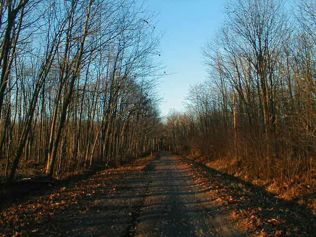
The lane carries no facilities of any kind. Nothing marks it as an attraction; there is neither a parking area nor a footpath, and the whole length is unlit. The public photograph of the site, taken by Craig M. Groshek and uploaded on 25 September 2005 under the description "Boy Scout Lane, Linwood, Wisconsin", shows an unpaved two-track between leafless hardwoods, with no gate and no barrier in view.
Sources consulted
- Samoset Council, Boy Scouts of America, «A Chronicle of the Boy Scouts of America in the Samoset Council, 1910 thru 1984» — Samoset Council, 1984 book
- Alexander Shaine, «In search of a real-life ghost story» — Stevens Point Journal, page A.1, 2005 newspaper archive
- Chad Lewis and Terry Fisk, «The Wisconsin Road Guide to Haunted Locations (ISBN 0-9762099-1-8)» — Unexplained Research Publishing Company, 2004 book
- Mike Conley, «Do ghostly Boy Scouts haunt rural lane?» — Marion (McDowell) News, 2007 newspaper archive
- OpenStreetMap contributors, «Boy Scout Lane, way 5673904 (highway=residential, TIGER-derived)» — OpenStreetMap, 2026 web
- English Wikipedia contributors, «Boy Scout Lane: revision history and File:BoyScoutLane.jpg upload metadata» — Wikimedia Foundation, 2005 archive
Reviewed by V. Serrano on 2026-09-07 · How we verify our content
💬 Field testimonies (0)
No testimonies yet. Add the first.
Add your testimony
🔒 Log in to add a testimony