👻 HAUNTED PLACE · EXP. Nº9478
ACTIVE
Devil's Tramping Ground
Devil's Tramping Ground is a location reputed to be haunted in North Carolina, US. Its reputation comes from reported apparitions, unexplained phenomena and eyewitness accounts gathered over time.
Where is Devil's Tramping Ground?
- Location
- North Carolina, US
- Type
- Forest / nature
- Coordinates
- 35.585, -79.487
- Testimonies
- 0
- Last updated
LOCATION
Why is Devil's Tramping Ground said to be haunted?
In a pine wood in the south-west of Chatham County, North Carolina, near Harper's Crossroads, lies the circle known since at least 1882 as the Devil's Tramping Ground. What the nineteenth century described was a ring rather than a clearing: a bare path about a foot wide enclosing a patch of wire grass. A letter to the Wilmington Star, reprinted by the Charlotte Home and Democrat on 20 January 1882, called it a circle "about twenty-five feet in diameter, as perfect as though drawn with compasses" and reported that the grass inside it never crossed the path. In 1905 G. W. Paschal of Wake Forest measured it for the News and Observer at "one hundred and twenty five feet around", with two paths crossing the middle at right angles, and ruled out trampling: "It is certain that no animal, human or brute, tramps regularly in these paths." John Harden gave it his book title in 1949 and printed the only laboratory result it has ever had. A century of campfires has since worn the whole clearing bare, and the ring is gone.
What is the history of Devil's Tramping Ground?
The circle reached print as a letter to a newspaper. The Wilmington Star ran it from Gulf, in the south-west of Chatham County, and the North Carolina weeklies passed it along: the Charlotte Home and Democrat printed it on page three on 20 January 1882 under the heading "A Curiosity", the Western Sentinel of Winston on 2 February, the Fairfield News and Herald of Winnsboro, South Carolina, on 8 February, the Orange County Observer of Hillsborough on 18 February, the Anderson Intelligencer on 9 March, and the Evening Star of Washington on 17 June, which kept the credit line "Gulf Letter in the Wilmington Star". Five months took the story from a county sheet to the capital. The correspondent claimed no discovery of his own. The place, he wrote, "has been known to the oldest inhabitant and his grand parents as the 'Devil's Tramping Ground.'"
What he described was a ring, and the ring was the bare part. "Situated in the woods and surrounded by giant trees, principally red oak and short-leaf pines, is a circle about twenty-five feet in diameter, as perfect as though drawn with compasses, the circle being marked by a path as clean cut as though used every day. Through the center another path, equally as clean, about one degree to the east of north and south; no paths to or from and none except cow-paths in the neighborhood." Inside the ring the ground carried "a thick growth of long wire grass (not another bunch of which grows within eight miles of the place) and which never crosses the path that marks the circle". He talked a local man into digging into it, "and after getting down about three feet and finding nothing he was so impressed with the supernatural origin that he refused to go any further". His reading had turned up only "the fabled fairy walks of Ireland and one place in Norway" as parallels, and he ended by asking the Star's readers for a theory of its "origin or use".
Twenty-three years later a named man measured it. G. W. Paschal of Wake Forest came out on a fishing party with J. George Hannah of Siler City, "Uncle Dowd Cheek", R. G. Hannah of Montgomery and R. L. Paschal of Fort Worth on Friday 21 July 1905, and wrote the trip up for the News and Observer of 30 July under the headline "Weird Tale of Fishing Frolic". He placed the site "on the road leading from Harper's Cross Roads to Coleridge, and about three miles from the former place" and gave numbers: "The Tramping Ground is a circle of wire grass, one hundred and twenty five feet around. It is bounded by a path about a foot wide, and crossed by two paths of the same width running through the centre almost at right angles. In all these paths nothing grows... The wire grass grows to the border, but not a sprig grows beyond or in the paths." Paschal also wrote down the explanation his neighbours gave him: "There is a legend that an Indian chief was buried here, and that squaws brought earth in blankets from beyond Deep River and planted it in wire grass." He dug at it with his knife and found an inch and a half of "bluish, clayey looking earth which is markedly different from that under the sedge immediately outside the circle", and concluded "it is evident that the earth was brought here".
The version everyone quotes is John Harden's. A Greensboro newspaperman who broadcast the radio series Tales of Tar Heelia, Harden gave the site the title chapter of The Devil's Tramping Ground and Other North Carolina Mystery Stories (University of North Carolina Press, 1949, pages 53-60). He put it "ten miles from Siler City" on the L. R. Down property, "a perfect circle with a forty-foot diameter" whose path "is about a foot wide and is barren of any obstruction - growing or otherwise", with "a certain variety of wire grass" inside and broomsedge and moss outside. He collected the rival origin stories - the war dances of the tribes who knew the country as the Great Flats, the burial of a Chief Croatan whose name the Roanoke colonists were said to have carved on their tree, the horses of a vanished molasses mill - and the local testimony, including the Siler City lawyer L. P. Dixon on a possum hunt whose dogs "lowered their tails, gave up the warm trail they were following, and dropped in behind their masters". His radio programme produced enough mail that he arranged for soil to be sampled, and that is where the science comes from.
Timeline: the documented record of Devil's Tramping Ground
- 20 January 1882 The Charlotte Home and Democrat reprints, on page three under the heading "A Curiosity", a letter to the Wilmington Star describing a twenty-five-foot circle in Chatham County ringed by a bare path. It is the earliest printed account of the site located in the Library of Congress newspaper corpus, and the letter itself says the name was already known to "the oldest inhabitant and his grand parents".
- 2 February 1882 The Western Sentinel of Winston reprints the letter on its front page with the credit "A correspondent of the Wilmington Star", which fixes the paper the letter was written for.
- 17 June 1882 The Evening Star of Washington runs the letter under the standing head "Gulf Letter in the Wilmington Star", placing the correspondent in Gulf, Chatham County, and carrying his closing appeal for a theory of the circle's "origin or use".
- 30 July 1905 G. W. Paschal of Wake Forest publishes in the News and Observer the first measured survey signed with a name: 125 feet around, a path a foot wide, two diametrical paths at right angles, and soil inside the ring that he judged had been carried there.
- 3 January 1935 Ed. S. Phillips discusses the site in "The Old Anson Road" in the Chatham Record, describing a "barren area" of some fifteen yards' radius with "strange grass", and reporting that water analysed from the district was found rich in salt.
- 1949 John Harden gives the site the title chapter of his book and prints the only laboratory result the legend has ever had: samples taken from the path by W. B. Morgan and tested by W. A. Bridges and Dr I. E. Miles, sterile because "so acid and so low in the necessary soil nutriments".
- 1952 Duke University Press publishes the first volume of the Frank C. Brown Collection of North Carolina Folklore, thirty-one years of state-wide collecting with two regular contributors working in Chatham County. The Devil's Tramping Ground does not appear in it.
- 2006 The Encyclopedia of North Carolina prints, in Kimberly Hewitt's entry, that the soil samples "proved to be sterile due to an extremely high salt content", fusing Bridges's acidity finding with Harry Davis's separate salt hypothesis. The sentence has been copied outward ever since.
- 2008 The North Carolina Department of Agriculture runs a soil chemical test on a sample taken inside the circle. The Chatham County Historical Association records the outcome as inconclusive, with repeated campfires a likely influence on the chemistry.
Is there a rational explanation for Devil's Tramping Ground?
The three eyewitness descriptions do not agree about the shape, and the disagreement is measurable. In 1882 the correspondent gave a circle "about twenty-five feet in diameter" with one path across the middle. In 1905 Paschal gave "a circle of wire grass, one hundred and twenty five feet around" - about forty feet across - with two crossing paths "almost at right angles". By 1949 Harden had the forty-foot circle and no crossing paths at all, and the diametrical paths have never come back into the story. Whatever the ring was, it grew by half in twenty-three years and then lost the feature that Paschal thought pointed to a grave: "The ends of the diametrical paths mark roughly the four points of the compass."
Paschal's own reasoning is still the best argument against the trampling explanations. He ruled out feet: "It is certain that no animal, human or brute, tramps regularly in these paths, or often enough to keep vegetation from springing up." He noted that the believers had not been there at night - "I have never heard that any of the defenders of this plausible theory ever in person investigated the matter" - and gave his reason for not going himself: "A midnight hour, a deep forest, and the presence of the devils, when taken together, are not favorable conditions for scientific work." Harden reported the same absence of witnesses in 1949, writing that "no person has ever spent the night there" to disprove the story.
The soil chemistry that everyone repeats has been garbled in transmission, and the garbling can be dated. Harden had samples taken from the middle of the path by the Siler City newspaperman W. B. Morgan and analysed by W. A. Bridges, of the W. A. Bridges Laboratory at Wilson, and by Dr I. E. Miles, director of the Soil Testing Division of the North Carolina Department of Agriculture. Bridges's report, as Harden quotes it, says nothing about salt: "Although there may be other factors of a physical nature that would make this a sterile soil, our findings show that plant life will not be supported on a soil that is so acid and so low in the necessary soil nutriments." Salt was a separate idea, and Harden labelled it: the "horse-back opinion" of Harry Davis, curator of the North Carolina State Museum, who had been in the area with the state geologist J. L. Stuckey testing wells for sodium chloride and had found old buffalo and deer licks. The two got welded together in the Encyclopedia of North Carolina in 2006, whose entry by Kimberly Hewitt states that samples "proved to be sterile due to an extremely high salt content" and cites Harden. The salt claim now attached to the site all over the web comes out of that sentence rather than out of any laboratory.
The one modern test was inconclusive, and the reason is the campfires. Chris Palmer's geology paper for the Chatham County Historical Association records that "a North Carolina Department of Agriculture soil chemical test was conducted in 2008 on a soil sample taken in the circle. Results are inconclusive and repeated fires may have influenced soil chemistry results." The same paper puts the site inside the Bennett Flatwoods, an area labelled "worthless land" in pencil on the 1852 Map Shewing the Routes of the Central and Cape Fear and Yadkin Railroads, "where ancient volcanic ash deposits create water-impermeable soils unsuitable for agriculture". A sterile patch in a district that a railway surveyor had already written off is a smaller anomaly than a sterile patch anywhere else.
The folklorists missed it. The Frank C. Brown Collection of North Carolina Folklore gathers what Duke University's collectors took down between 1912 and 1943, and volume one, Games and Rhymes, Beliefs and Customs, Riddles, Proverbs, Speech, Tales and Legends, contains no Tramping Ground: a case-insensitive count of the root tramp over its 276,671 words returns two occurrences, "trampled underfoot" and the title of a song, against 63 occurrences of Chatham and 122 of devil in the same file. Two of Brown's most productive contributors, Clara Hearne of Pittsboro and Lucille Cheek, were collecting in Chatham itself. Volumes six and seven, the popular beliefs and superstitions, give the same result. The best-known circle in the state is absent from the state's own folklore corpus.
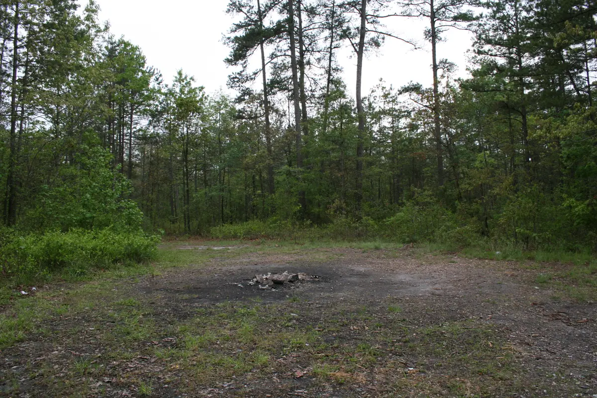
The photograph on this page is the last piece of evidence, and it is against the legend. It was taken by Jason Horne on 5 May 2007 and shows a broad trampled clearing with a burnt fire pit at the centre, litter at the edges and grass growing across the middle of the bare ground. The picture shows neither the ring nor the foot-wide path nor the island of wire grass. Palmer's paper says the ground "has been used for campfires by visitors", and that is what the picture shows: the thing the 1882 and 1905 letters described has been camped out of existence.
Can you visit Devil's Tramping Ground?
The site lies at the end of Devils Tramping Ground Road, off NC 902 near Harper's Crossroads in the Bear Creek township of Chatham County; OpenStreetMap, consulted on 7 September 2026, returns "Devils Tramping Ground Road, Harpers Crossroads, Chatham County, North Carolina, 27207" for the coordinates on this page. Paschal in 1905 gave the same approach from the other end: "on the road leading from Harper's Cross Roads to Coleridge, and about three miles from the former place". The site carries neither museum nor ticket office nor interpretive panel, and nobody is on duty there. Harden's line from 1949 still describes the arrangement: the spot "has no more official marking or designation than a state highway sign at Harper Cross Roads, one mile distant, pointing to the odd spot".
The land around the clearing is private and lived on - the addressed buildings on that road are houses - so this page gives no street number and no route through the woods. The Chatham County Historical Association's own geology paper describes the ground as one "used for campfires by visitors", which is the condition the 2008 soil test blamed for its inconclusive result.
The file, on the other hand, is open and free. The 1882 reprints and the 1905 article are online in full at the Library of Congress: the Charlotte Home and Democrat of 20 January 1882 (page 3), the Western Sentinel of 2 February 1882 (page 1), the Evening Star of Washington of 17 June 1882 (page 6, the cleanest text of the letter) and the News and Observer of 30 July 1905 (page 11, Paschal's article, headed "Weird Tale of Fishing Frolic"). Harden's 1949 book is on the Internet Archive. Chris Palmer's "Chatham County Geologic Facts and Oddities", revision 1.4 of August 2025, is a free PDF on the Chatham County Historical Association's website and carries the 2008 soil result, the 1852 railroad map and a photograph of visitors at the circle captioned "circa late 1800s". For the recent literature, Palmer's bibliography lists M. C. Weston, "Night at the Devil's Tramping Ground", Chatham Magazine, September-October 2023, pages 44-46, an account of a "limited study" carried out on the spot, and Ed. S. Phillips, "The Old Anson Road", Chatham Record, 3 January 1935.
Sources consulted
- Correspondent of the Wilmington Star, «A Curiosity [letter of a correspondent of the Wilmington Star, reprinted]» — Charlotte Home and Democrat, 1882 newspaper archive
- Correspondent of the Wilmington Star, «The Devil's Tramping Ground - Gulf Letter in the Wilmington Star» — Evening Star (Washington, D.C.), 1882 newspaper archive
- G. W. Paschal, «Weird Tale of Fishing Frolic. Not of Fish Caught, but of Sights Seen» — The News and Observer (Raleigh), 1905 newspaper archive
- John Harden, «The Devil's Tramping Ground and Other North Carolina Mystery Stories, pp. 53-60» — University of North Carolina Press, 1949 book
- Frank C. Brown (collector); Paull F. Baum (general editor), «The Frank C. Brown Collection of North Carolina Folklore, vol. 1: Games and Rhymes, Beliefs and Customs, Riddles, Proverbs, Speech, Tales and Legends» — Duke University Press, 1952 book
- Kimberly Hewitt, «Devil's Tramping Ground, in the Encyclopedia of North Carolina» — NCpedia / University of North Carolina Press, 2006 web
- Chris Palmer, «Chatham County Geologic Facts and Oddities, rev. 1.4» — Chatham County Historical Association, 2025 report
- Correspondent of the Wilmington Star, «A Curiosity [reprint crediting "a correspondent of the Wilmington Star"]» — Western Sentinel (Winston, N.C.), 1882 newspaper archive
Reviewed by V. Serrano on 2026-09-07 · How we verify our content
💬 Field testimonies (0)
No testimonies yet. Add the first.
Add your testimony
🔒 Log in to add a testimony